
Carte topographique Gerlachovský štít
Carte interactive
Cliquez sur la carte pour afficher l’altitude.
À propos de cette carte
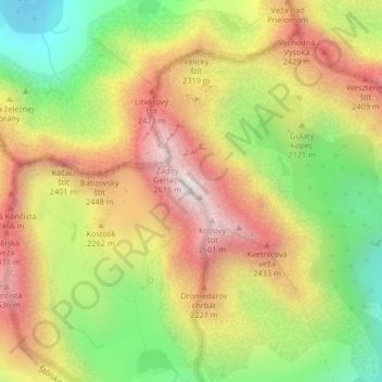
Nom : Carte topographique Gerlachovský štít, altitude, relief.
Altitude moyenne : 2 103 m
Altitude minimum : 1 571 m
Altitude maximum : 2 618 m
Gerlachovský štít (Slovak pronunciation (help·info), translated into English as Gerlachov Peak, German: Gerlsdorfer Spitze, Hungarian: Gerlachfalvi-csúcs), informally referred to as Gerlach, is the highest peak in the High Tatras, in Slovakia, and in the Carpathian Mountains. Its elevation is usually listed at 2654.4 m above mean sea level. The pyramidal shape of the massif is marked by a huge cirque. Despite its relatively low elevation, Gerlachovský štít features a vertical rise of approximately 2,000 metres (6,600 ft) above the valley floor.
Autres cartes topographiques
Cliquez sur une carte pour visualiser sa topographie, son altitude et son relief.
Kriváň
Slovakia > Region of Prešov > District of Poprad > Vysoké Tatry
Kriváň, Vysoké Tatry, District of Poprad, Region of Prešov, Eastern Slovakia, Slovakia
Altitude moyenne : 1 913 m