
Carte topographique Huailai County
Carte interactive
Cliquez sur la carte pour afficher l’altitude.
À propos de cette carte
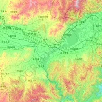
Nom : Carte topographique Huailai County, altitude, relief.
Lieu : Huailai County, Zhangjiakou, Hebei, China (40.06413 115.27853 40.58777 115.96294)
Altitude moyenne : 840 m
Altitude minimum : 234 m
Altitude maximum : 2 218 m
Huailai County has a monsoon-influenced, continental semi-arid climate (Köppen BSk), with cold, dry, and windy winters and hot, humid summers, with temperatures slightly warmer than Zhangjiakou due to the more southerly location but still significantly cooler than in Beijing due to the high elevation. The monthly 24-hour average temperature ranges from −7.0 °C (19.4 °F) in January to 24.8 °C (76.6 °F) in July, and the annual mean is 10.01 °C (50.0 °F). A majority of the annual rainfall occurs in July and August alone. With monthly percent possible sunshine ranging from 60% in July to 73% in January and February, sunshine is abundant year-round, totalling about 3,030 hours annually.
Autres cartes topographiques
Cliquez sur une carte pour visualiser sa topographie, son altitude et son relief.
Zhangjiakou
China > Hebei > Zhangjiakou
Zhangjiakou, Qiaoxi District, Zhangjiakou City, Hebei, 075000, China
Altitude moyenne : 959 m
Chongli District
China > Hebei > Zhangjiakou
Chongli District, Zhangjiakou, Hebei, 076300, China
Altitude moyenne : 1 448 m