
Carte topographique Zhangjiakou
Carte interactive
Cliquez sur la carte pour afficher l’altitude.
À propos de cette carte
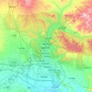
Nom : Carte topographique Zhangjiakou, altitude, relief.
Altitude moyenne : 959 m
Altitude minimum : 633 m
Altitude maximum : 1 764 m
Lying in between the Mongolian Plateau and the North China Plain, Zhangjiakou has a somewhat rugged topography characterized by high mountains, deep valleys, and rocky pathways. As a result, it serves as a perfect natural screen for Beijing, which has made it a strategic priority militarily since ancient times. It is called "The Gateway to Beijing" and "The Mountain City beyond the Great Wall". The grand Yan Mountain, the towering Taihang Mountain, the vast grasslands, and the meandering Sangyang River converge here. The city government has regarded tourism as a major driving force of the city's economy and continues to develop the industry.
Autres cartes topographiques
Cliquez sur une carte pour visualiser sa topographie, son altitude et son relief.
Chongli District
China > Hebei > Zhangjiakou
Chongli District, Zhangjiakou, Hebei, 076300, China
Altitude moyenne : 1 448 m
Huailai County
China > Hebei > Zhangjiakou
Huailai County, Zhangjiakou, Hebei, China
Altitude moyenne : 840 m