
Faire un don
Équipez-vous pour votre prochaine aventure :
En tant que Partenaire Amazon, ce site perçoit une commission sur les achats éligibles sans surcoût pour vous.
Carte topographique Elk Mountain
Cliquez sur la carte pour afficher l’altitude.
Faire un don
Équipez-vous pour votre prochaine aventure :
En tant que Partenaire Amazon, ce site perçoit une commission sur les achats éligibles sans surcoût pour vous.
À propos de cette carte
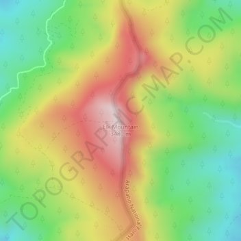
Nom : Carte topographique Elk Mountain, altitude, relief.
Lieu : Elk Mountain, Grand County, Colorado, United States (40.16188 -106.12841 40.16198 -106.12831)
Altitude moyenne : 3 218 m
Altitude minimum : 2 994 m
Altitude maximum : 3 482 m
Faire un don
Équipez-vous pour votre prochaine aventure :
En tant que Partenaire Amazon, ce site perçoit une commission sur les achats éligibles sans surcoût pour vous.
Autres cartes topographiques
Cliquez sur une carte pour visualiser sa topographie, son altitude et son relief.
Fraser
United States > Colorado > Grand County
Fraser is located in southeastern Grand County at 39°56′39″N 105°48′48″W / 39.94417°N 105.81333°W / 39.94417; -105.81333 (39.944158, -105.813355), at an elevation of 8,574 feet (2,613 m) above sea level. It is bordered to the south by the town of Winter Park and to the north by…
Altitude moyenne : 2 696 m
Faire un don
Équipez-vous pour votre prochaine aventure :
En tant que Partenaire Amazon, ce site perçoit une commission sur les achats éligibles sans surcoût pour vous.
Hot Sulphur Springs
United States > Colorado > Grand County
Hot Sulphur Springs is a statutory town and the county seat of Grand County, Colorado, United States. The town is located near Byers Canyon between Granby and Kremmling, 95 miles (153 km) northwest of Denver and 30 miles (48 km) northwest of Winter Park. The town population was 687 at the 2020 census. Its…
Altitude moyenne : 2 446 m