
Faire un don
Équipez-vous pour votre prochaine aventure :
En tant que Partenaire Amazon, ce site perçoit une commission sur les achats éligibles sans surcoût pour vous.
Carte topographique Fraser
Cliquez sur la carte pour afficher l’altitude.
Faire un don
Équipez-vous pour votre prochaine aventure :
En tant que Partenaire Amazon, ce site perçoit une commission sur les achats éligibles sans surcoût pour vous.
Fraser
Fraser is located in southeastern Grand County at 39°56′39″N 105°48′48″W / 39.94417°N 105.81333°W / 39.94417; -105.81333 (39.944158, -105.813355), at an elevation of 8,574 feet (2,613 m) above sea level. It is bordered to the south by the town of Winter Park and to the north by unincorporated Tabernash. U.S. Route 40 leads south and east across Berthoud Pass 71 miles (114 km) to Denver, and northwest 15 miles (24 km) to Granby, the largest town in Grand County.
Faire un don
Équipez-vous pour votre prochaine aventure :
En tant que Partenaire Amazon, ce site perçoit une commission sur les achats éligibles sans surcoût pour vous.
À propos de cette carte
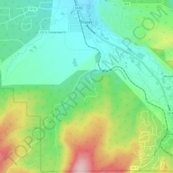
Nom : Carte topographique Fraser, altitude, relief.
Lieu : Fraser, Grand County, Colorado, 80442, United States (39.90779 -105.82230 39.95298 -105.77621)
Altitude moyenne : 2 696 m
Altitude minimum : 2 599 m
Altitude maximum : 2 888 m
Faire un don
Équipez-vous pour votre prochaine aventure :
En tant que Partenaire Amazon, ce site perçoit une commission sur les achats éligibles sans surcoût pour vous.
Autres cartes topographiques
Cliquez sur une carte pour visualiser sa topographie, son altitude et son relief.
Tabernash
United States > Colorado > Grand County
On August 10, 1984, a Cessna L-19 Bird Dog (registration N4584A), piloted by James Jeb Caddell, 36, crashed in a forest near Tabernash. The aircraft was en route from Granby to Jeffco Airport, Colorado. The wreckage was found by backpackers three years later on August 23, 1987. A 6½ minute video shot from a…
Altitude moyenne : 2 592 m
Faire un don
Équipez-vous pour votre prochaine aventure :
En tant que Partenaire Amazon, ce site perçoit une commission sur les achats éligibles sans surcoût pour vous.
Rabbit Ears Pass
United States > Colorado > Grand County
Although lower in elevation than many of the high mountain passes farther to the south in the Colorado Rockies, Rabbit Ears Pass often receives a great deal of snow in winter and is subject to regular short closures during heavy winter storms. The seasonal snowpack on this pass is a major source of water for…
Altitude moyenne : 2 852 m
Faire un don
Équipez-vous pour votre prochaine aventure :
En tant que Partenaire Amazon, ce site perçoit une commission sur les achats éligibles sans surcoût pour vous.
Radium
United States > Colorado > Grand County
Radium, elevation 6,890 feet (2,100 m), is a small rural unincorporated community in southwestern Grand County, Colorado, United States. The community sits in the mountains along an isolated stretch of Colorado River downstream from Gore Canyon and southwest of Kremmling. The mainline of the Denver and Rio…
Altitude moyenne : 2 261 m
Hot Sulphur Springs
United States > Colorado > Grand County
Hot Sulphur Springs is a statutory town and the county seat of Grand County, Colorado, United States. The town is located near Byers Canyon between Granby and Kremmling, 95 miles (153 km) northwest of Denver and 30 miles (48 km) northwest of Winter Park. The town population was 687 at the 2020 census. Its…
Altitude moyenne : 2 446 m
Faire un don
Équipez-vous pour votre prochaine aventure :
En tant que Partenaire Amazon, ce site perçoit une commission sur les achats éligibles sans surcoût pour vous.