
Carte topographique Vysoké Tatry
Carte interactive
Cliquez sur la carte pour afficher l’altitude.
À propos de cette carte
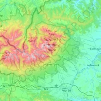
Nom : Carte topographique Vysoké Tatry, altitude, relief.
Lieu : Vysoké Tatry, District of Poprad, Region of Prešov, Slovakia (49.08034 19.88393 49.28609 20.38501)
Altitude moyenne : 1 024 m
Altitude minimum : 568 m
Altitude maximum : 2 593 m
The town of Vysoké Tatry is special in many aspects. It is not a true town, but a conglomerate of separate and different settlements (originally separate villages), whose only common feature is that they are the main tourist resorts in the Slovak High Tatras, while being connected through a common railway network (the Tatra Railway). After the country's capital, the town is Slovakia's major tourist destination. It has around 4,000 inhabitants, excluding tourists. It is located at an elevation of 1,010 m (3,310 ft) above sea level. Covering 360.22 square kilometres (139.1 square miles), it is Slovakia's second-largest urban area, after the country's capital, and was the largest until 2007, when the village of Štrbské Pleso became a part of Štrba after Štrba's municipal government's successful claim on the Supreme Court.
Autres cartes topographiques
Cliquez sur une carte pour visualiser sa topographie, son altitude et son relief.
Rysy
Slovakia > Region of Prešov > District of Poprad > Vysoké Tatry
Rysy, Vysoké Tatry, District of Poprad, Region of Prešov, Slovakia
Altitude moyenne : 2 005 m
Poprad
Slovakia > Region of Prešov > District of Poprad
Poprad, District of Poprad, Region of Prešov, Slovakia
Altitude moyenne : 709 m