
Carte topographique Waiouru
Carte interactive
Cliquez sur la carte pour afficher l’altitude.
À propos de cette carte
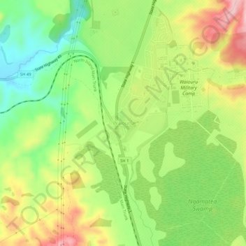
Nom : Carte topographique Waiouru, altitude, relief.
Altitude moyenne : 817 m
Altitude minimum : 727 m
Altitude maximum : 929 m
Because of its high altitude and close proximity to Mt Ruapehu, Waiouru's climate is cold throughout the year, unlike other North Island centres, and particularly cold when the wind blows from the mountain. The Desert Road is regularly closed in winter owing to heavy snowfalls. Waiouru's climate can be described as continental.However according to the Köppen Climate Classification, the climate is an oceanic climate (cfb)
Autres cartes topographiques
Cliquez sur une carte pour visualiser sa topographie, son altitude et son relief.
Whakapapa Island
New Zealand > Manawatu-Whanganui > Ruapehu District
Whakapapa Island, Ruapehu District, Manawatū-Whanganui, New Zealand
Altitude moyenne : 544 m
Tongariro National Park
New Zealand > Manawatu-Whanganui > Ruapehu District
Tongariro National Park, Ruapehu District, Manawatū-Whanganui, New Zealand
Altitude moyenne : 888 m
Erua
New Zealand > Manawatu-Whanganui > Ruapehu District
Erua, Ruapehu District, Manawatū-Whanganui, New Zealand
Altitude moyenne : 845 m
Mount Ruapehu
New Zealand > Manawatu-Whanganui > Ruapehu District
Mount Ruapehu, Ruapehu District, Manawatū-Whanganui, New Zealand
Altitude moyenne : 2 474 m
Mount Tongariro
New Zealand > Manawatu-Whanganui > Ruapehu District
Mount Tongariro, Ruapehu District, Manawatū-Whanganui, New Zealand
Altitude moyenne : 1 675 m