
Carte topographique Tongariro National Park
Carte interactive
Cliquez sur la carte pour afficher l’altitude.
À propos de cette carte
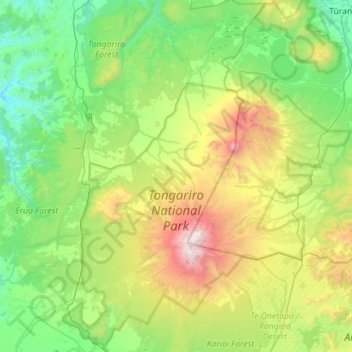
Nom : Carte topographique Tongariro National Park, altitude, relief.
Altitude moyenne : 888 m
Altitude minimum : 214 m
Altitude maximum : 2 746 m
Like the whole of New Zealand, Tongariro National Park is situated in a temperate zone. The prevailing westerly winds gather water over the Tasman Sea. As the volcanoes of Tongariro National Park are the first significant elevations that these winds encounter on the North Island, besides Mount Taranaki, rain falls almost daily. The east–west rainfall differences are not as great as in the Southern Alps, because the three volcanoes do not belong to a greater mountain range, but there is still a noticeable rain shadow effect with the Rangipo desert on the Eastern leeward side receiving 1,000 mm of annual rainfall. At Whakapapa Village (1119 m) the average annual rainfall is about 2200 mm, in Ohakune (610 m) about 1250 mm and in higher altitudes, such as Iwikau Village (1770 m), about 4900 mm. In winter there is snow to about 1500 m. Temperatures vary dramatically, even within one day. In Whakapapa, they can fall below the freezing point all year round. The average temperature is 13 °C, with a maximum of 25 °C in summer and a minimum of -10 °C in winter. In some summers the summits of the three volcanoes are covered with snow; on top of Mount Ruapehu, snow fields can be found every summer and the summit is glaciated.
Autres cartes topographiques
Cliquez sur une carte pour visualiser sa topographie, son altitude et son relief.
Waiouru
New Zealand > Manawatu-Whanganui > Ruapehu District
Waiouru, Ruapehu District, Manawatū-Whanganui, 4825, New Zealand
Altitude moyenne : 817 m
Whakapapa Island
New Zealand > Manawatu-Whanganui > Ruapehu District
Whakapapa Island, Ruapehu District, Manawatū-Whanganui, New Zealand
Altitude moyenne : 544 m
Erua
New Zealand > Manawatu-Whanganui > Ruapehu District
Erua, Ruapehu District, Manawatū-Whanganui, New Zealand
Altitude moyenne : 845 m
Mount Ruapehu
New Zealand > Manawatu-Whanganui > Ruapehu District
Mount Ruapehu, Ruapehu District, Manawatū-Whanganui, New Zealand
Altitude moyenne : 2 474 m
Mount Tongariro
New Zealand > Manawatu-Whanganui > Ruapehu District
Mount Tongariro, Ruapehu District, Manawatū-Whanganui, New Zealand
Altitude moyenne : 1 675 m