
Carte topographique Xã Hòa Ninh
Carte interactive
Cliquez sur la carte pour afficher l’altitude.
À propos de cette carte
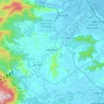
Nom : Carte topographique Xã Hòa Ninh, altitude, relief.
Lieu : Xã Hòa Ninh, Hòa Vang District, Đà Nẵng, Vietnam (15.99451 107.95789 16.10739 108.09236)
Altitude moyenne : 108 m
Altitude minimum : -2 m
Altitude maximum : 989 m
Autres cartes topographiques
Cliquez sur une carte pour visualiser sa topographie, son altitude et son relief.
Ban Co Peak
Ban Co Peak, Đường Lê Văn Lương, Phường Thọ Quang, Sơn Trà District, Đà Nẵng, 50207, Vietnam
Altitude moyenne : 308 m
Bán đảo Sơn Trà
Bán đảo Sơn Trà, Phường Thọ Quang, Sơn Trà District, Da Nang, Vietnam
Altitude moyenne : 285 m
Cam Le River
Cam Le River, Cẩm Lệ District, Da Nang, 550000, Vietnam
Altitude moyenne : 5 m