
Carte topographique Cẩm Lệ District
Carte interactive
Cliquez sur la carte pour afficher l’altitude.
À propos de cette carte
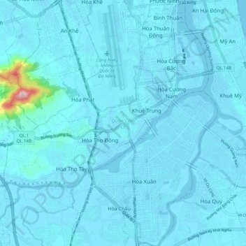
Nom : Carte topographique Cẩm Lệ District, altitude, relief.
Lieu : Cẩm Lệ District, Đà Nẵng, Vietnam (15.97164 108.15769 16.06202 108.23951)
Altitude moyenne : 14 m
Altitude minimum : -3 m
Altitude maximum : 315 m
Autres cartes topographiques
Cliquez sur une carte pour visualiser sa topographie, son altitude et son relief.
Xã Hòa Ninh
Xã Hòa Ninh, Hòa Vang District, Đà Nẵng, Vietnam
Altitude moyenne : 108 m
Ban Co Peak
Ban Co Peak, Đường Lê Văn Lương, Phường Thọ Quang, Sơn Trà District, Đà Nẵng, 50207, Vietnam
Altitude moyenne : 308 m
Bán đảo Sơn Trà
Bán đảo Sơn Trà, Phường Thọ Quang, Sơn Trà District, Da Nang, Vietnam
Altitude moyenne : 285 m
Cam Le River
Cam Le River, Cẩm Lệ District, Da Nang, 550000, Vietnam
Altitude moyenne : 5 m