
Carte topographique Kakuma
Carte interactive
Cliquez sur la carte pour afficher l’altitude.
À propos de cette carte
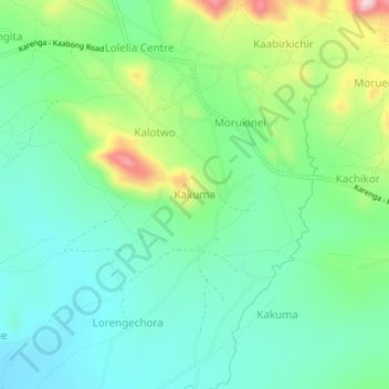
Nom : Carte topographique Kakuma, altitude, relief.
Lieu : Kakuma, Kaabong, Northern Region, Uganda (3.50100 34.02919 3.54100 34.06919)
Altitude moyenne : 1 535 m
Altitude minimum : 1 458 m
Altitude maximum : 1 722 m
Autres cartes topographiques
Cliquez sur une carte pour visualiser sa topographie, son altitude et son relief.
Mount Morungole
Mount Morungole, Kaabong, Northern Region, Uganda
Altitude moyenne : 2 388 m
Kidepo Valley National Park
Kidepo Valley National Park, Kaabong, Northern Region, Uganda
Altitude moyenne : 1 309 m