
Carte topographique Peerless Lake
Carte interactive
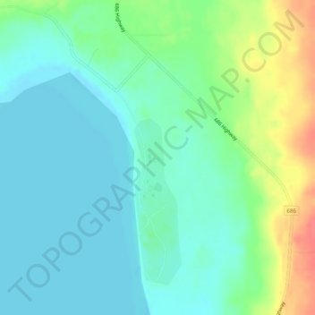
Cliquez sur la carte pour afficher l’altitude.
À propos de cette carte
Nom : Carte topographique Peerless Lake, altitude, relief.
Altitude moyenne : 703 m
Altitude minimum : 687 m
Altitude maximum : 745 m
Peerless Lake is an unincorporated community in northern Alberta, Canada. It is located on the northeastern shore of Peerless Lake, approximately 70 kilometres (43 mi) northeast of Red Earth Creek, and has an elevation of 695 metres (2,280 ft).
Autres cartes topographiques
Cliquez sur une carte pour visualiser sa topographie, son altitude et son relief.
Calling Lake
Canada > Alberta > Municipal District of Opportunity > Calling Lake
Calling Lake, Municipal District of Opportunity, Alberta, T0G 0K0, Canada
Altitude moyenne : 609 m
Red Earth Creek
Canada > Alberta > Municipal District of Opportunity > Red Earth Creek
Red Earth Creek, Municipal District of Opportunity, Alberta, T0G 1X0, Canada
Altitude moyenne : 549 m
Wabasca-Desmarais
Canada > Alberta > Municipal District of Opportunity > Wabasca-Desmarais
Wabasca-Desmarais, Municipal District of Opportunity, Alberta, T0G 2K0, Canada
Altitude moyenne : 556 m