
Faire un don
Équipez-vous pour votre prochaine aventure :
En tant que Partenaire Amazon, ce site perçoit une commission sur les achats éligibles sans surcoût pour vous.
Carte topographique Manawatū District
Cliquez sur la carte pour afficher l’altitude.
Faire un don
Équipez-vous pour votre prochaine aventure :
En tant que Partenaire Amazon, ce site perçoit une commission sur les achats éligibles sans surcoût pour vous.
À propos de cette carte
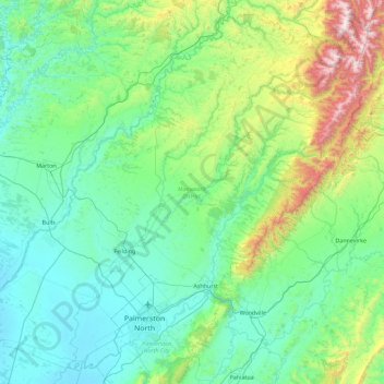
Nom : Carte topographique Manawatū District, altitude, relief.
Lieu : Manawatū District, Manawatū-Whanganui, New Zealand (-40.44154 175.22137 -39.79805 176.12693)
Altitude moyenne : 309 m
Altitude minimum : 5 m
Altitude maximum : 1 722 m
Faire un don
Équipez-vous pour votre prochaine aventure :
En tant que Partenaire Amazon, ce site perçoit une commission sur les achats éligibles sans surcoût pour vous.
Autres cartes topographiques
Cliquez sur une carte pour visualiser sa topographie, son altitude et son relief.
Palmerston North
New Zealand > Manawatu-Whanganui > Palmerston North City
Although the land Palmerston North is situated on is bounded by the lofty Ruahine and Tararua ranges in the east and south respectively, the city has a predominantly flat appearance. The occasional rise in elevation occurs further away from the river and is especially pronounced in the north and northeast, and…
Altitude moyenne : 118 m
Faire un don
Équipez-vous pour votre prochaine aventure :
En tant que Partenaire Amazon, ce site perçoit une commission sur les achats éligibles sans surcoût pour vous.
Taumarunui
New Zealand > Manawatu-Whanganui > Ruapehu District
Under the Köppen, Taumarunui has an Oceanic climate:(Cfb). Due to location, low altitude and Geography surroundings, Taumarunui is more liable to warm to hot summers than other central North Island centres and in winter Taumarunui is cold and frosty. Rainfall yearly is 1,449 mm (57.047244 in). Annual sunshine…
Altitude moyenne : 245 m
Faire un don
Équipez-vous pour votre prochaine aventure :
En tant que Partenaire Amazon, ce site perçoit une commission sur les achats éligibles sans surcoût pour vous.
Faire un don
Équipez-vous pour votre prochaine aventure :
En tant que Partenaire Amazon, ce site perçoit une commission sur les achats éligibles sans surcoût pour vous.
Mount Tongariro
New Zealand > Manawatu-Whanganui > Ruapehu District
The high altitude and severe alpine climate between March and October allow snowfall in the winter (there are commercial ski-fields at neighbouring Mount Ruapehu) and rain can freeze, causing verglas; in contrast in the mid to late summer, the mountains can be bare apart from remnant patches of snow in…
Altitude moyenne : 1 675 m
Pohangina
New Zealand > Manawatu-Whanganui > Manawatū District
Pohangina is located along the foot of the Ruahine Range, and is primarily farming land. Farming varies from sheep and cattle to crops of maize and 'chow'. The farmland was originally ancient native forest. Rimu and northern rātā grew above 1000 feet, with kamahi, kaikawaka and pink pine growing at higher…
Altitude moyenne : 190 m
Faire un don
Équipez-vous pour votre prochaine aventure :
En tant que Partenaire Amazon, ce site perçoit une commission sur les achats éligibles sans surcoût pour vous.
Faire un don
Équipez-vous pour votre prochaine aventure :
En tant que Partenaire Amazon, ce site perçoit une commission sur les achats éligibles sans surcoût pour vous.
Faire un don
Équipez-vous pour votre prochaine aventure :
En tant que Partenaire Amazon, ce site perçoit une commission sur les achats éligibles sans surcoût pour vous.
Awahou North
New Zealand > Manawatu-Whanganui > Manawatū District > Pohangina
Altitude moyenne : 174 m
Faire un don
Équipez-vous pour votre prochaine aventure :
En tant que Partenaire Amazon, ce site perçoit une commission sur les achats éligibles sans surcoût pour vous.
Mount Ruapehu
New Zealand > Manawatu-Whanganui > Ruapehu District
Ruapehu has a polar tundra climate (Köppen: ET) on the upper slopes, with average temperatures ranging from −4 to 15 °C (25 to 59 °F) in summer and −7 to 7 °C (19 to 45 °F) in winter, depending on elevation and cloudiness. On the lower slopes, Ruapehu has a subpolar oceanic climate (Köppen: Cfc).
Altitude moyenne : 2 474 m
Faire un don
Équipez-vous pour votre prochaine aventure :
En tant que Partenaire Amazon, ce site perçoit une commission sur les achats éligibles sans surcoût pour vous.
Lake Wiritoa
New Zealand > Manawatu-Whanganui > Whanganui District > Whanganui > Pauri Village
Altitude moyenne : 50 m
Kaitoke Lake
New Zealand > Manawatu-Whanganui > Whanganui District > Whanganui
Altitude moyenne : 41 m
Lake Pauri
New Zealand > Manawatu-Whanganui > Whanganui District > Whanganui > Pauri Village
Altitude moyenne : 57 m
Faire un don
Équipez-vous pour votre prochaine aventure :
En tant que Partenaire Amazon, ce site perçoit une commission sur les achats éligibles sans surcoût pour vous.
Faire un don
Équipez-vous pour votre prochaine aventure :
En tant que Partenaire Amazon, ce site perçoit une commission sur les achats éligibles sans surcoût pour vous.
Palmerston North
New Zealand > Manawatu-Whanganui > Palmerston North City
Although the land Palmerston North is situated on is bounded by the lofty Ruahine and Tararua ranges in the east and south respectively, the city has a predominantly flat appearance. The occasional rise in elevation occurs further away from the river and is especially pronounced in the north and northeast, and…
Altitude moyenne : 118 m
Ohakune
New Zealand > Manawatu-Whanganui > Ruapehu District
Ohakune is located in the Ruapehu District and the Manawatū-Whanganui region, to the immediate south-west of the slopes of the Mount Ruapehu stratovolcano. The associated Ohakune volcanic complex is just to the north of the town and the small maar lakes Rangatauanui and Rangatauaiti are to the south of the…
Altitude moyenne : 619 m
Faire un don
Équipez-vous pour votre prochaine aventure :
En tant que Partenaire Amazon, ce site perçoit une commission sur les achats éligibles sans surcoût pour vous.
Faire un don
Équipez-vous pour votre prochaine aventure :
En tant que Partenaire Amazon, ce site perçoit une commission sur les achats éligibles sans surcoût pour vous.
Pauri Village
New Zealand > Manawatu-Whanganui > Whanganui District > Whanganui
Altitude moyenne : 50 m
Taumarunui
New Zealand > Manawatu-Whanganui > Ruapehu District
Under the Köppen, Taumarunui has an Oceanic climate:(Cfb). Due to location, low altitude and Geography surroundings, Taumarunui is more liable to warm to hot summers than other central North Island centres and in winter, Taumarunui is cold and frosty. Rainfall yearly is 1,449 mm (57.047244 in). Annual…
Altitude moyenne : 245 m
Faire un don
Équipez-vous pour votre prochaine aventure :
En tant que Partenaire Amazon, ce site perçoit une commission sur les achats éligibles sans surcoût pour vous.
Kitchener Park
New Zealand > Manawatu-Whanganui > Manawatū District > Feilding
Altitude moyenne : 63 m
Waiouru
New Zealand > Manawatu-Whanganui > Ruapehu District
Because of its high altitude and close proximity to Mt Ruapehu, Waiouru's climate is cold throughout the year, unlike other North Island centres, and particularly cold when the wind blows from the mountain. The Desert Road is regularly closed in winter owing to heavy snowfalls. Waiouru's climate can be…
Altitude moyenne : 817 m
Faire un don
Équipez-vous pour votre prochaine aventure :
En tant que Partenaire Amazon, ce site perçoit une commission sur les achats éligibles sans surcoût pour vous.
Faire un don
Équipez-vous pour votre prochaine aventure :
En tant que Partenaire Amazon, ce site perçoit une commission sur les achats éligibles sans surcoût pour vous.
Waiouru
New Zealand > Manawatu-Whanganui > Ruapehu District
Because of its high altitude and close proximity to Mt Ruapehu, Waiouru's climate is cold throughout the year, unlike other North Island centres, and particularly cold when the wind blows from the mountain. The Desert Road is regularly closed in winter owing to heavy snowfalls. Waiouru's climate can be…
Altitude moyenne : 817 m
Mount Tongariro
New Zealand > Manawatu-Whanganui > Ruapehu District
The high altitude and severe alpine climate between March and October allow snowfall in the winter (there are commercial ski-fields at neighbouring Mount Ruapehu) and rain can freeze, causing verglas; in contrast in the mid to late summer, the mountains can be bare apart from remnant patches of snow in…
Altitude moyenne : 1 675 m
Faire un don
Équipez-vous pour votre prochaine aventure :
En tant que Partenaire Amazon, ce site perçoit une commission sur les achats éligibles sans surcoût pour vous.
Faire un don
Équipez-vous pour votre prochaine aventure :
En tant que Partenaire Amazon, ce site perçoit une commission sur les achats éligibles sans surcoût pour vous.
Faire un don
Équipez-vous pour votre prochaine aventure :
En tant que Partenaire Amazon, ce site perçoit une commission sur les achats éligibles sans surcoût pour vous.
Mount Ruapehu
New Zealand > Manawatu-Whanganui > Ruapehu District
Ruapehu has a polar tundra climate (Köppen: ET) on the upper slopes, with average temperatures ranging from −4–15 °C in summer and −7–7 °C in winter, depending on elevation and cloudiness. On the lower slopes, Ruapehu has a subpolar oceanic climate (Köppen: Cfc).
Altitude moyenne : 2 474 m
Faire un don
Équipez-vous pour votre prochaine aventure :
En tant que Partenaire Amazon, ce site perçoit une commission sur les achats éligibles sans surcoût pour vous.
Faire un don
Équipez-vous pour votre prochaine aventure :
En tant que Partenaire Amazon, ce site perçoit une commission sur les achats éligibles sans surcoût pour vous.