
Faire un don
Équipez-vous pour votre prochaine aventure :
En tant que Partenaire Amazon, ce site perçoit une commission sur les achats éligibles sans surcoût pour vous.
Carte topographique Pohangina
Cliquez sur la carte pour afficher l’altitude.
Faire un don
Équipez-vous pour votre prochaine aventure :
En tant que Partenaire Amazon, ce site perçoit une commission sur les achats éligibles sans surcoût pour vous.
Pohangina
Pohangina is located along the foot of the Ruahine Range, and is primarily farming land. Farming varies from sheep and cattle to crops of maize and 'chow'. The farmland was originally ancient native forest. Rimu and northern rātā grew above 1000 feet, with kamahi, kaikawaka and pink pine growing at higher and steeper slopes, leatherwood scrub growing at higher altitudes, and wild tussocks growing at the summits of the range.
Faire un don
Équipez-vous pour votre prochaine aventure :
En tant que Partenaire Amazon, ce site perçoit une commission sur les achats éligibles sans surcoût pour vous.
À propos de cette carte
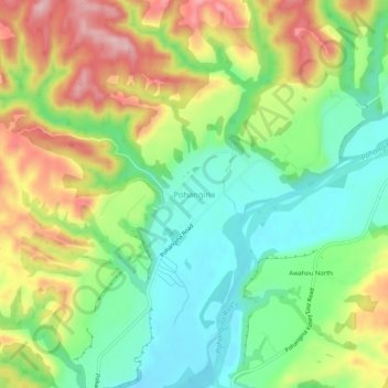
Nom : Carte topographique Pohangina, altitude, relief.
Altitude moyenne : 190 m
Altitude minimum : 104 m
Altitude maximum : 313 m
Faire un don
Équipez-vous pour votre prochaine aventure :
En tant que Partenaire Amazon, ce site perçoit une commission sur les achats éligibles sans surcoût pour vous.
Autres cartes topographiques
Cliquez sur une carte pour visualiser sa topographie, son altitude et son relief.
Kitchener Park
New Zealand > Manawatu-Whanganui > Manawatū District > Feilding
Altitude moyenne : 63 m
Faire un don
Équipez-vous pour votre prochaine aventure :
En tant que Partenaire Amazon, ce site perçoit une commission sur les achats éligibles sans surcoût pour vous.