
Carte topographique Chautauqua County
Carte interactive
Cliquez sur la carte pour afficher l’altitude.
À propos de cette carte
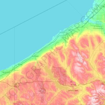
Nom : Carte topographique Chautauqua County, altitude, relief.
Lieu : Chautauqua County, New York, United States (41.99833 -79.76198 42.69143 -79.05921)
Altitude moyenne : 328 m
Altitude minimum : 170 m
Altitude maximum : 668 m
The county is generally composed of rolling hills and valleys, with elevations ranging anywhere between 1100 and 2100 feet, although the land within a few miles of Lake Erie is generally flat and at an elevation of 1000 feet or lower. The lowest point in the county is Lake Erie, at 571 feet (174 meters), and the highest point is Gurnsey Benchmark at 2,180 feet (660 meters).
Autres cartes topographiques
Cliquez sur une carte pour visualiser sa topographie, son altitude et son relief.
Village of East Hampton
United States > New York > Suffolk County > Town of East Hampton
Village of East Hampton, Town of East Hampton, Suffolk County, New York, United States
Altitude moyenne : 7 m
Village of Black River
United States > New York > Jefferson County
Village of Black River, Town of Le Ray, Jefferson County, New York, United States
Altitude moyenne : 193 m
Watkins Glen
United States > New York > Schuyler County > Watkins Glen
Watkins Glen, Schuyler County, New York, United States
Altitude moyenne : 179 m
Newtonville
United States > New York > Town of Colonie > Newtonville
Newtonville, Town of Colonie, Albany County, New York, 12128, United States
Altitude moyenne : 97 m
Parish
United States > New York > Parish
Parish, Town of Parish, Oswego County, New York, 13131, United States
Altitude moyenne : 147 m
Village of Shoreham
United States > New York > Suffolk County > Town of Brookhaven
Village of Shoreham, Town of Brookhaven, Suffolk County, New York, United States
Altitude moyenne : 33 m