
Carte topographique Broome County
Carte interactive
Cliquez sur la carte pour afficher l’altitude.
À propos de cette carte
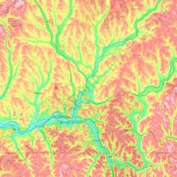
Nom : Carte topographique Broome County, altitude, relief.
Lieu : Broome County, New York, United States (41.99790 -76.13017 42.41554 -75.35955)
Altitude moyenne : 413 m
Altitude minimum : 241 m
Altitude maximum : 635 m
The county's western portion is hilly, with wide valleys that accommodate Binghamton and its suburbs. In the northern portion, Interstate 81 traverses a wide glacial valley. The eastern part of the county is much more rugged, as the land rises to the Catskill Mountains. The terrain generally slopes to the west. The county's highest point is in the southeast of the county, a U.S. National Geodetic Survey benchmark known as Slawson atop an unnamed hill in the Town of Sanford. It is approximately 2087 feet (636 m) above sea level. An area due east on the Delaware County line in Oquaga Creek State Park also lies within the same elevation contour line. The lowest point is 864 feet (263 m) above sea level, along the Susquehanna River, at the Pennsylvania state line.
Autres cartes topographiques
Cliquez sur une carte pour visualiser sa topographie, son altitude et son relief.
Village of East Hampton
United States > New York > Suffolk County > Town of East Hampton
Village of East Hampton, Town of East Hampton, Suffolk County, New York, United States
Altitude moyenne : 7 m
Village of Black River
United States > New York > Jefferson County
Village of Black River, Town of Le Ray, Jefferson County, New York, United States
Altitude moyenne : 193 m
Chautauqua County
Chautauqua County, New York, United States
Altitude moyenne : 328 m
Watkins Glen
United States > New York > Schuyler County > Watkins Glen
Watkins Glen, Schuyler County, New York, United States
Altitude moyenne : 179 m
Newtonville
United States > New York > Town of Colonie > Newtonville
Newtonville, Town of Colonie, Albany County, New York, 12128, United States
Altitude moyenne : 97 m
Parish
United States > New York > Parish
Parish, Town of Parish, Oswego County, New York, 13131, United States
Altitude moyenne : 147 m
Village of Shoreham
United States > New York > Suffolk County > Town of Brookhaven
Village of Shoreham, Town of Brookhaven, Suffolk County, New York, United States
Altitude moyenne : 33 m