
Carte topographique Hanzhong
Carte interactive
Cliquez sur la carte pour afficher l’altitude.
À propos de cette carte
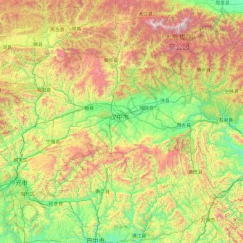
Nom : Carte topographique Hanzhong, altitude, relief.
Lieu : Hanzhong, Shaanxi, 723000, China (32.14553 105.48730 33.87930 108.28281)
Altitude moyenne : 1 165 m
Altitude minimum : 328 m
Altitude maximum : 3 668 m
The Qin Mountains to the north help shield the city from cold Siberian winds in the winter. Hence, the winter in Hanzhong is warmer than that at similar latitudes east of Shannan. This is despite Hanzhong's elevation and inland location.
Autres cartes topographiques
Cliquez sur une carte pour visualiser sa topographie, son altitude et son relief.
Lintong District
Lintong District, Xi'an, Shaanxi, 710600, China
Altitude moyenne : 463 m
Fuping County
China > Shaanxi > Weinan City
Fuping County, Weinan City, Shaanxi, China
Altitude moyenne : 675 m
Xi'an
China > Shaanxi > Weiyang District > Xi'an
Xi'an, Weiyang District, Xi'an, Shaanxi, 710018, China
Altitude moyenne : 412 m
Baota District
China > Shaanxi > Yan'an City
Baota District, Yan'an City, Shaanxi, 716000, China
Altitude moyenne : 1 180 m
Ankang City
China > Shaanxi > Ankang City
Ankang City, Shaanxi, 725100, China
Altitude moyenne : 1 071 m
Huanglong County
Huanglong County, Yan'an, Shaanxi, China
Altitude moyenne : 1 275 m