
Carte topographique Mount Taibai
Carte interactive
Cliquez sur la carte pour afficher l’altitude.
Mount Taibai
The base of the mountain is composed of stone covered by yellow loess soil, while the middle elevations of the mountain are covered with hardy trees and spectacular rocky outcrops. The higher elevations of the mountain contain glacial remnants, cirque, peaks, aulacogen, and moraine, all of which have proven of great use toward geological research.
À propos de cette carte
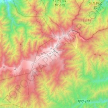
Nom : Carte topographique Mount Taibai, altitude, relief.
Lieu : Mount Taibai, Xi'an, Shaanxi, China (33.89966 107.57555 33.99678 107.83978)
Altitude moyenne : 2 314 m
Altitude minimum : 1 001 m
Altitude maximum : 3 755 m
Autres cartes topographiques
Cliquez sur une carte pour visualiser sa topographie, son altitude et son relief.