
Faire un don
Équipez-vous pour votre prochaine aventure :
En tant que Partenaire Amazon, ce site perçoit une commission sur les achats éligibles sans surcoût pour vous.
Carte topographique Capital Regional District
Cliquez sur la carte pour afficher l’altitude.
Faire un don
Équipez-vous pour votre prochaine aventure :
En tant que Partenaire Amazon, ce site perçoit une commission sur les achats éligibles sans surcoût pour vous.
À propos de cette carte
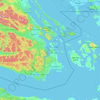
Nom : Carte topographique Capital Regional District, altitude, relief.
Lieu : Capital Regional District, British Columbia, Canada (48.22456 -124.50400 49.01702 -123.00850)
Altitude moyenne : 140 m
Altitude minimum : -2 m
Altitude maximum : 1 458 m
Faire un don
Équipez-vous pour votre prochaine aventure :
En tant que Partenaire Amazon, ce site perçoit une commission sur les achats éligibles sans surcoût pour vous.
Autres cartes topographiques
Cliquez sur une carte pour visualiser sa topographie, son altitude et son relief.
Kootenay National Park
Canada > British Columbia > Regional District of East Kootenay
Kootenay National Park is a national park of Canada in southeastern British Columbia. The park consists of 1,406 km2 (543 sq mi) of the Canadian Rockies, including parts of the Kootenay and Park mountain ranges, the Kootenay River and the entirety of the Vermilion River. While the Vermilion River is completely…
Altitude moyenne : 1 832 m
El Capitan Mountain
Canada > British Columbia > Cowichan Valley Regional District > Area I (Youbou / Meade Creek)
Altitude moyenne : 1 005 m
Seymour Arm
Canada > British Columbia > Columbia-Shuswap Regional District > Area F (Scotch Creek/Seymour Arm)
Altitude moyenne : 381 m
Mayor Island
Canada > British Columbia > Regional District of Mount Waddington > Area A (Seymour Inlet/Knight Inlet)
Altitude moyenne : 5 m
Faire un don
Équipez-vous pour votre prochaine aventure :
En tant que Partenaire Amazon, ce site perçoit une commission sur les achats éligibles sans surcoût pour vous.
Dawsons Landing
Canada > British Columbia > Central Coast Regional District > Area A (Ocean Falls/Outer Coast)
Altitude moyenne : 207 m
Black Mountain (South Summit)
Canada > British Columbia > Metro Vancouver Regional District > West Vancouver
Altitude moyenne : 936 m
Kingsvale
Canada > British Columbia > Thompson-Nicola Regional District > Area N (Beautiful Nicola Valley - South)
Altitude moyenne : 928 m
Eagle Mountain
Canada > British Columbia > Fraser Valley Regional District > Abbotsford
Altitude moyenne : 128 m
Faire un don
Équipez-vous pour votre prochaine aventure :
En tant que Partenaire Amazon, ce site perçoit une commission sur les achats éligibles sans surcoût pour vous.
Cultus Lake
Canada > British Columbia > Fraser Valley Regional District > Area H (Cultus Lake/Columbia Valley) > Cultus Lake
Altitude moyenne : 191 m
The Copilot
Canada > British Columbia > Squamish-Lillooet Regional District > Area D (Elaho/Garibaldi)
Altitude moyenne : 1 468 m
Upper Fraser
Canada > British Columbia > Regional District of Fraser-Fort George > Area F (Willow River/Upper Fraser)
Altitude moyenne : 647 m
Faire un don
Équipez-vous pour votre prochaine aventure :
En tant que Partenaire Amazon, ce site perçoit une commission sur les achats éligibles sans surcoût pour vous.
Mount Hermann
Canada > British Columbia > Peace River Regional District > Tumbler Ridge
Altitude moyenne : 1 439 m
Mount Vernon
Canada > British Columbia > Cowichan Valley Regional District > Area F (Cowichan Lake South / Skutz Falls)
Altitude moyenne : 622 m
Carbon Peak
Canada > British Columbia > Peace River Regional District > Area E (Moberly Lake/Sukunka Valley)
Altitude moyenne : 1 421 m
Kendrick Point
Canada > British Columbia > North Coast Regional District > Area E (Moresby Island)
Altitude moyenne : 40 m
Faire un don
Équipez-vous pour votre prochaine aventure :
En tant que Partenaire Amazon, ce site perçoit une commission sur les achats éligibles sans surcoût pour vous.
South Hazelton
Canada > British Columbia > Regional District of Kitimat-Stikine > Area B (Suskwa/Kitwanga/Kispiox)
Altitude moyenne : 278 m
Pinder Peak
Canada > British Columbia > Regional District of Mount Waddington > Area D (Nimpkish Valley/Cormorant Island)
Altitude moyenne : 872 m
Fairmont Hot Springs
Canada > British Columbia > Regional District of East Kootenay > Area F (Columbia Lake/Windermere Lake)
Altitude moyenne : 920 m
Big Lake Ranch
Canada > British Columbia > Cariboo Regional District > Area F (Horsefly/Likely/150 Mile House)
Altitude moyenne : 908 m
Faire un don
Équipez-vous pour votre prochaine aventure :
En tant que Partenaire Amazon, ce site perçoit une commission sur les achats éligibles sans surcoût pour vous.
Tsay Keh Dene Nation
Canada > British Columbia > Peace River Regional District > Area B (Finlay Valley/Beatton Valley)
Altitude moyenne : 688 m
Topaz Lake
Canada > British Columbia > Regional District of East Kootenay > Area G (Forster Creek/Mount Assiniboine)
Altitude moyenne : 1 149 m
Mount Connor
Canada > British Columbia > Regional District of East Kootenay > Area A (Upper Flathead/Elk Valley)
Altitude moyenne : 2 466 m
Denarta Park
Canada > British Columbia > Regional District of Kitimat-Stikine > Area C (Butedale/Kitlope/Kitsumkalum)
Altitude moyenne : 155 m
Faire un don
Équipez-vous pour votre prochaine aventure :
En tant que Partenaire Amazon, ce site perçoit une commission sur les achats éligibles sans surcoût pour vous.
Van Somer Point
Canada > British Columbia > Peace River Regional District > Area B (Finlay Valley/Beatton Valley)
Altitude moyenne : 670 m
Honeymoon Island
Canada > British Columbia > Regional District of Bulkley-Nechako > Area C (Stuart Lake/Omineca Valley)
Altitude moyenne : 862 m
Grotto Falls
Canada > British Columbia > Fraser Valley Regional District > Area F (McConnell Creek/Hatzic Prairie)
Altitude moyenne : 715 m
Marshall Ridge
Canada > British Columbia > Squamish-Lillooet Regional District > Area A (Upper Bridge River Valley)
Altitude moyenne : 1 214 m
Faire un don
Équipez-vous pour votre prochaine aventure :
En tant que Partenaire Amazon, ce site perçoit une commission sur les achats éligibles sans surcoût pour vous.
Calkins Creek
Canada > British Columbia > Fraser Valley Regional District > Chilliwack
Altitude moyenne : 102 m
Arden Islet
Canada > British Columbia > Capital Regional District > Juan de Fuca Electoral Area
Altitude moyenne : 50 m
Sonora Park
Canada > British Columbia > Regional District of Central Okanagan > Kelowna
Altitude moyenne : 418 m
Faire un don
Équipez-vous pour votre prochaine aventure :
En tant que Partenaire Amazon, ce site perçoit une commission sur les achats éligibles sans surcoût pour vous.
Eagle Bay
Canada > British Columbia > Columbia-Shuswap Regional District > Area C (Blind Bay/Sorrento)
Altitude moyenne : 497 m
Baynes Lake
Canada > British Columbia > Regional District of East Kootenay > Area B (Lake Koocanusa)
Altitude moyenne : 796 m
Big Lake
Canada > British Columbia > Cariboo Regional District > Area J (West Chilcotin)
Altitude moyenne : 1 330 m
Panorama Ridge
Canada > British Columbia > Central Coast Regional District > Area C (Hagensborg/Talchako/Atnarko)
Altitude moyenne : 2 203 m
Faire un don
Équipez-vous pour votre prochaine aventure :
En tant que Partenaire Amazon, ce site perçoit une commission sur les achats éligibles sans surcoût pour vous.
Dragon Cone
Canada > British Columbia > Thompson-Nicola Regional District > Area A (Wells Gray Country)
Altitude moyenne : 1 703 m
Escalante River
Canada > British Columbia > Alberni-Clayoquot Regional District > Area C (Long Beach)
Altitude moyenne : 390 m
Diamond Island
Canada > British Columbia > Cariboo Regional District > Area A (Red Bluff/Quesnel South) > Alexandria
Altitude moyenne : 471 m
Black Creek
Canada > British Columbia > Comox Valley Regional District > Area C (Puntledge/Black Creek)
Altitude moyenne : 60 m
Faire un don
Équipez-vous pour votre prochaine aventure :
En tant que Partenaire Amazon, ce site perçoit une commission sur les achats éligibles sans surcoût pour vous.
Fraser River
Canada > British Columbia > Fraser Valley Regional District > Chilliwack > Minto Landing
Altitude moyenne : 100 m
Faire un don
Équipez-vous pour votre prochaine aventure :
En tant que Partenaire Amazon, ce site perçoit une commission sur les achats éligibles sans surcoût pour vous.
Hillcrest Park
Canada > British Columbia > Metro Vancouver Regional District > Vancouver
Altitude moyenne : 76 m
Ruby Creek
Canada > British Columbia > Fraser Valley Regional District > Skawahlook > Ruby Creek
Altitude moyenne : 169 m
Mount McKinley
Canada > British Columbia > Regional District of Kootenay Boundary > Area D (Granby Valley)
Altitude moyenne : 1 221 m
Black Bear Ridge
Canada > British Columbia > Peace River Regional District > Area B (Finlay Valley/Beatton Valley)
Altitude moyenne : 1 314 m
Faire un don
Équipez-vous pour votre prochaine aventure :
En tant que Partenaire Amazon, ce site perçoit une commission sur les achats éligibles sans surcoût pour vous.
Shirley
Canada > British Columbia > Capital Regional District > Juan de Fuca Electoral Area
Altitude moyenne : 79 m
Hudson Bay Mountain
Canada > British Columbia > Regional District of Bulkley-Nechako > Area A (Hudson Bay Mountain)
Altitude moyenne : 2 064 m
Faire un don
Équipez-vous pour votre prochaine aventure :
En tant que Partenaire Amazon, ce site perçoit une commission sur les achats éligibles sans surcoût pour vous.
Mount Sylvia
Canada > British Columbia > Northern Rockies Regional Municipality
Altitude moyenne : 2 288 m
Silverthrone Mountain
Canada > British Columbia > Regional District of Mount Waddington > Area A (Seymour Inlet/Knight Inlet)
Mount Silverthrone is perhaps one of the most heavily is perhaps one of the most heavily glaciated volcanic peaks in southwestern British Columbia. It has a topographic prominence of approximately 975 m (3,200 ft), greater than any other volcano in southwestern British Columbia. The extensive icefields around…
Altitude moyenne : 2 297 m
San Juan Ridge
Canada > British Columbia > Capital Regional District > Juan de Fuca Electoral Area
Altitude moyenne : 841 m
Thor
Canada > British Columbia > Columbia-Shuswap Regional District > Area A (Kicking Horse/Kinbasket Lake)
Altitude moyenne : 2 605 m
Faire un don
Équipez-vous pour votre prochaine aventure :
En tant que Partenaire Amazon, ce site perçoit une commission sur les achats éligibles sans surcoût pour vous.
Cliff Falls
Canada > British Columbia > Metro Vancouver Regional District > Maple Ridge
Altitude moyenne : 106 m
Namu
Canada > British Columbia > Central Coast Regional District > Area A (Ocean Falls/Outer Coast)
Altitude moyenne : 126 m
Blue Lake
Canada > British Columbia > Regional District of East Kootenay > Area A (Upper Flathead/Elk Valley)
Altitude moyenne : 1 430 m
Blind Bay
Canada > British Columbia > Columbia-Shuswap Regional District > Area C (Blind Bay/Sorrento)
Altitude moyenne : 414 m
Faire un don
Équipez-vous pour votre prochaine aventure :
En tant que Partenaire Amazon, ce site perçoit une commission sur les achats éligibles sans surcoût pour vous.
Halcyon
Canada > British Columbia > Regional District of Central Kootenay > Area K (The Arrow Lakes)
Altitude moyenne : 721 m
Cedar
Canada > British Columbia > Regional District of Nanaimo > Area A (Cassidy/Cedar)
Altitude moyenne : 27 m
Trail Ridge
Canada > British Columbia > Cariboo Regional District > Area K (East Chilcotin)
Altitude moyenne : 2 366 m
Mount Baldy
Canada > British Columbia > qathet Regional District > Area A (Malaspina/Toba)
Altitude moyenne : 1 246 m
Faire un don
Équipez-vous pour votre prochaine aventure :
En tant que Partenaire Amazon, ce site perçoit une commission sur les achats éligibles sans surcoût pour vous.
Whistler
Canada > British Columbia > Squamish-Lillooet Regional District > Whistler Resort Municipality > Whistler
Altitude moyenne : 996 m
Cherryville
Canada > British Columbia > Regional District of North Okanagan > Area E (Cherryville/East Creighton)
Altitude moyenne : 643 m
Meziadin Junction
Canada > British Columbia > Regional District of Kitimat-Stikine > Area A (Nass Valley/Bell Irving)
Altitude moyenne : 347 m
Taurus Mountain
Canada > British Columbia > Regional District of East Kootenay > Area G (Forster Creek/Mount Assiniboine)
Altitude moyenne : 2 404 m
Faire un don
Équipez-vous pour votre prochaine aventure :
En tant que Partenaire Amazon, ce site perçoit une commission sur les achats éligibles sans surcoût pour vous.
Record Mountain
Canada > British Columbia > Regional District of Kootenay Boundary > Rossland
Altitude moyenne : 1 802 m
Corbin
Canada > British Columbia > Regional District of East Kootenay > Area A (Upper Flathead/Elk Valley)
Altitude moyenne : 1 635 m
Bella Coola
Canada > British Columbia > Central Coast Regional District > Area E (West Bella Coola/Clayton Falls/Tallheo)
There is a 454 km mostly paved road connection by Highway 20 to Williams Lake. The road was built in 1953 by local residents, and features a 15 km ascent from the Valley floor to the Chilcotin plateau, gaining 1600m in elevation to the summit at Heckman Pass, via a number of steep grades & switchbacks. The…
Altitude moyenne : 437 m
Spences Bridge
Canada > British Columbia > Thompson-Nicola Regional District > Area I (Blue Sky Country)
Spences Bridge's location is mountainous, with higher elevations part of the Interior Plateau. The east side of the Fraser here is part of the Clear Range, a mountainous southwards extension of the Fraser Plateau located in the angle of the Thompson and Fraser Rivers. Arthur Seat lies in that range on the west…
Altitude moyenne : 495 m
Faire un don
Équipez-vous pour votre prochaine aventure :
En tant que Partenaire Amazon, ce site perçoit une commission sur les achats éligibles sans surcoût pour vous.
Black Canyon
Canada > British Columbia > Thompson-Nicola Regional District > Area I (Blue Sky Country)
Altitude moyenne : 386 m
Dark Mountain
Canada > British Columbia > Regional District of Kitimat-Stikine > Area F (Dease Lake)
Altitude moyenne : 1 649 m
Ghost Peak
Canada > British Columbia > Columbia-Shuswap Regional District > Area B (Shelter Bay/Mica Creek)
Altitude moyenne : 2 101 m
Faire un don
Équipez-vous pour votre prochaine aventure :
En tant que Partenaire Amazon, ce site perçoit une commission sur les achats éligibles sans surcoût pour vous.
Whiteswan Lake
Canada > British Columbia > Regional District of East Kootenay > Area F (Columbia Lake/Windermere Lake)
Altitude moyenne : 1 392 m
Galiano
Canada > British Columbia > Capital Regional District > Southern Gulf Islands Electoral Area
Altitude moyenne : 82 m
Waveland
Canada > British Columbia > Comox Valley Regional District > Area B (Lazo North)
Altitude moyenne : 38 m
Wadhams
Canada > British Columbia > Central Coast Regional District > Area A (Ocean Falls/Outer Coast)
Altitude moyenne : 254 m
Faire un don
Équipez-vous pour votre prochaine aventure :
En tant que Partenaire Amazon, ce site perçoit une commission sur les achats éligibles sans surcoût pour vous.
Telegraph Creek
Canada > British Columbia > Central Coast Regional District > Area C (Hagensborg/Talchako/Atnarko)
Altitude moyenne : 1 432 m
Edwards Islet
Canada > British Columbia > North Coast Regional District > Area C (South Skeena)
Altitude moyenne : 26 m
Mission Ridge
Canada > British Columbia > Squamish-Lillooet Regional District > Area A (Upper Bridge River Valley)
Altitude moyenne : 1 526 m
Faire un don
Équipez-vous pour votre prochaine aventure :
En tant que Partenaire Amazon, ce site perçoit une commission sur les achats éligibles sans surcoût pour vous.
Mistaya Mountain
Canada > British Columbia > Columbia-Shuswap Regional District > Area A (Kicking Horse/Kinbasket Lake)
Altitude moyenne : 2 574 m
Mount Cooper
Canada > British Columbia > Regional District of Central Kootenay > Area D (Lardeau Valley/Duncan Lake)
Altitude moyenne : 2 481 m
McCall Island
Canada > British Columbia > Alberni-Clayoquot Regional District > Area C (Long Beach)
Altitude moyenne : 16 m
Faire un don
Équipez-vous pour votre prochaine aventure :
En tant que Partenaire Amazon, ce site perçoit une commission sur les achats éligibles sans surcoût pour vous.
Enderby
Canada > British Columbia > Regional District of North Okanagan > Enderby > Enderby
Latitude-Longitude: 50°33′03.0″N 119°08′22.7″W / 50.550833°N 119.139639°W / 50.550833; -119.139639 elevation: 360 metres
Altitude moyenne : 511 m
Wedgemount Lake
Canada > British Columbia > Squamish-Lillooet Regional District > Area C (Pemberton Valley/Mount Currie/D'Arcy)
Altitude moyenne : 2 088 m
Minnow Creek
Canada > British Columbia > Regional District of East Kootenay > Area G (Forster Creek/Mount Assiniboine)
Altitude moyenne : 1 428 m
Squamish
Canada > British Columbia > Squamish-Lillooet Regional District > Squamish
Altitude moyenne : 847 m
Faire un don
Équipez-vous pour votre prochaine aventure :
En tant que Partenaire Amazon, ce site perçoit une commission sur les achats éligibles sans surcoût pour vous.
Manson Creek
Canada > British Columbia > Regional District of Bulkley-Nechako > Area C (Stuart Lake/Omineca Valley)
Altitude moyenne : 1 035 m
Chilliwack
Canada > British Columbia > Fraser Valley Regional District > Chilliwack
Altitude moyenne : 392 m
Spotted Lake
Canada > British Columbia > Regional District of Okanagan-Similkameen > Area A (Osoyoos Lake)
Altitude moyenne : 607 m
Eva Lake Park
Canada > British Columbia > Squamish-Lillooet Regional District > Whistler Resort Municipality
Altitude moyenne : 760 m
Faire un don
Équipez-vous pour votre prochaine aventure :
En tant que Partenaire Amazon, ce site perçoit une commission sur les achats éligibles sans surcoût pour vous.
Rocky Mountains
Canada > British Columbia > Area A (Upper Flathead/Elk Valley)
Altitude moyenne : 2 231 m
Lone Butte
Canada > British Columbia > Area L (Lone Butte/Interlakes) > Lone Butte
At an elevation of approximately 3700 feet above sea level, Lone Butte marks the highest point on the Pacific Great Eastern Railway (now known as CN Rail), which arrived in the community by 1921.
Altitude moyenne : 1 159 m
Olalla
Canada > British Columbia > Area G (Upper Similkameen/Hedley) > Olalla
Altitude moyenne : 912 m
Mount Price
Canada > British Columbia > Squamish-Lillooet Regional District > Area D (Elaho/Garibaldi)
Mount Price is a small stratovolcano in the Garibaldi Ranges of the Pacific Ranges in southwestern British Columbia, Canada. It is located 10 km (6.2 mi) southeast of the abandoned settlement of Garibaldi above the eastern flank of the Cheakamus River valley. With a summit elevation of 2,049 m (6,722 ft), it…
Altitude moyenne : 1 672 m
Faire un don
Équipez-vous pour votre prochaine aventure :
En tant que Partenaire Amazon, ce site perçoit une commission sur les achats éligibles sans surcoût pour vous.