Géolocaliser

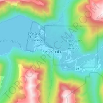
Carte topographique Bella Coola

Cliquez sur la carte pour afficher l’altitude.

Bella Coola

There is a 454 km mostly paved road connection by Highway 20 to Williams Lake. The road was built in 1953 by local residents, and features a 15 km ascent from the Valley floor to the Chilcotin plateau, gaining 1600m in elevation to the summit at Heckman Pass, via a number of steep grades & switchbacks. The construction of this road was described in the books "Bella Coola" and "A Road Runs West".

Wikipedia (CC-BY-SA 3.0)

À propos de cette carte

Nom : Carte topographique Bella Coola, altitude, relief.

Lieu : Bella Coola, Area E (West Bella Coola/Clayton Falls/Tallheo), Central Coast Regional District, British Columbia, V0T 1C0, Canada (52.33228 -126.79565 52.41228 -126.71565)

Altitude moyenne : 437 m

Altitude minimum : -1 m

Altitude maximum : 1 609 m

Équipez-vous pour votre prochaine aventure :

🛰️GPS de randonnée portable - Appareil robuste avec cartographie intégrée pour les zones sans réseau
🔥Réchauds de camping - Réchauds portables pour cuisine outdoor
🥤Poches à eau - Systèmes d'hydratation pour sac à dos
🧤Gants chauffants rechargeables - Le confort ultime pour la cartographie hivernale
📦Sacs de compression - Optimisation de l'espace

En tant que Partenaire Amazon, ce site perçoit une commission sur les achats éligibles sans surcoût pour vous.