
Faire un don
Équipez-vous pour votre prochaine aventure :
En tant que Partenaire Amazon, ce site perçoit une commission sur les achats éligibles sans surcoût pour vous.
Carte topographique Cernavoda
Cliquez sur la carte pour afficher l’altitude.
Faire un don
Équipez-vous pour votre prochaine aventure :
En tant que Partenaire Amazon, ce site perçoit une commission sur les achats éligibles sans surcoût pour vous.
À propos de cette carte
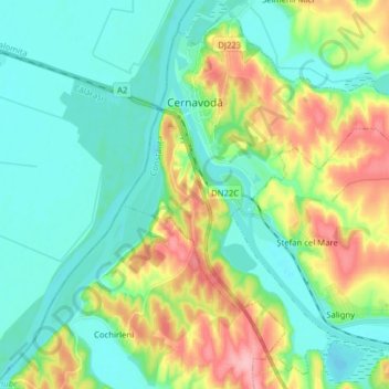
Nom : Carte topographique Cernavoda, altitude, relief.
Lieu : Cernavoda, Constanța, 905200, Romania (44.26177 28.00194 44.36788 28.15946)
Altitude moyenne : 39 m
Altitude minimum : 2 m
Altitude maximum : 128 m
Faire un don
Équipez-vous pour votre prochaine aventure :
En tant que Partenaire Amazon, ce site perçoit une commission sur les achats éligibles sans surcoût pour vous.
Autres cartes topographiques
Cliquez sur une carte pour visualiser sa topographie, son altitude et son relief.
Dobrogea
Except for the Danube Delta, a marshy region located in its northeastern corner, Dobruja is hilly, with an average altitude of about 200–300 metres. The highest point is the Țuțuiatu (Greci) Peak in the Măcin Mountains, having a height of 467 m. The Dobruja Plateau covers most of the Romanian part of…
Altitude moyenne : 53 m
Faire un don
Équipez-vous pour votre prochaine aventure :
En tant que Partenaire Amazon, ce site perçoit une commission sur les achats éligibles sans surcoût pour vous.
Faire un don
Équipez-vous pour votre prochaine aventure :
En tant que Partenaire Amazon, ce site perçoit une commission sur les achats éligibles sans surcoût pour vous.