
Faire un don
Équipez-vous pour votre prochaine aventure :
En tant que Partenaire Amazon, ce site perçoit une commission sur les achats éligibles sans surcoût pour vous.
Carte topographique Dobrogea
Cliquez sur la carte pour afficher l’altitude.
Faire un don
Équipez-vous pour votre prochaine aventure :
En tant que Partenaire Amazon, ce site perçoit une commission sur les achats éligibles sans surcoût pour vous.
Dobrogea
Except for the Danube Delta, a marshy region located in its northeastern corner, Dobruja is hilly, with an average altitude of about 200–300 metres. The highest point is the Țuțuiatu (Greci) Peak in the Măcin Mountains, having a height of 467 m. The Dobruja Plateau covers most of the Romanian part of Dobruja. The Ludogorie Plateau is found in Bulgaria. Lake Razelm is one of the most important lakes in Northern Dobruja.
Faire un don
Équipez-vous pour votre prochaine aventure :
En tant que Partenaire Amazon, ce site perçoit une commission sur les achats éligibles sans surcoût pour vous.
À propos de cette carte
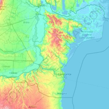
Nom : Carte topographique Dobrogea, altitude, relief.
Lieu : Dobrogea, Grădina, Constanța, 907277, Romania (43.52455 27.39217 45.52455 29.39217)
Altitude moyenne : 53 m
Altitude minimum : -4 m
Altitude maximum : 478 m
Faire un don
Équipez-vous pour votre prochaine aventure :
En tant que Partenaire Amazon, ce site perçoit une commission sur les achats éligibles sans surcoût pour vous.