
Carte topographique Dundagas novads
Carte interactive
Cliquez sur la carte pour afficher l’altitude.
À propos de cette carte
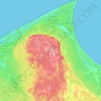
Nom : Carte topographique Dundagas novads, altitude, relief.
Lieu : Dundagas novads, Koerland, Letland (57.39463 22.07709 57.75912 22.61573)
Altitude moyenne : 27 m
Altitude minimum : 0 m
Altitude maximum : 99 m
Autres cartes topographiques
Cliquez sur une carte pour visualiser sa topographie, son altitude et son relief.
Bigauņciems
Letland > Koerland > Tukuma novads > Lapmežciema pagasts
Bigauņciems, Lapmežciema pagasts, Tukuma novads, Koerland, Letland
Altitude moyenne : 2 m