Géolocaliser

Carte topographique Tukuma novads

Carte interactive

Cliquez sur la carte pour afficher l’altitude.

À propos de cette carte

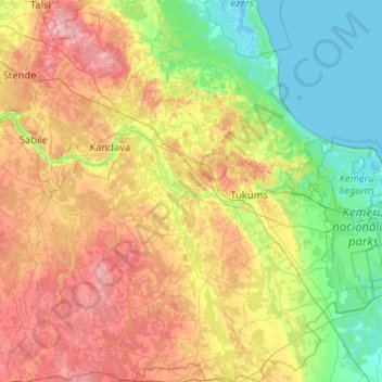
Nom : Carte topographique Tukuma novads, altitude, relief.

Lieu : Tukuma novads, Koerland, Letland (56.69129 22.80607 57.25229 23.50617)

Altitude moyenne : 58 m

Altitude minimum : -2 m

Altitude maximum : 170 m

Autres cartes topographiques

Cliquez sur une carte pour visualiser sa topographie, son altitude et son relief.

Tukuma novads

Letland > Koerland

Tukuma novads, Koerland, Letland

Altitude moyenne : 52 m

Bigauņciems

Letland > Koerland > Tukuma novads > Lapmežciema pagasts

Bigauņciems, Lapmežciema pagasts, Tukuma novads, Koerland, Letland

Altitude moyenne : 2 m

Vīdale

Letland > Koerland

Vīdale, Dundagas novads, Koerland, Letland

Altitude moyenne : 38 m

Burtnieki

Letland > Koerland > Burtnieki

Burtnieki, Tukuma novads, Letland

Altitude moyenne : 62 m

Engures novads

Letland > Koerland

Engures novads, Koerland, Letland

Altitude moyenne : 23 m

Engure

Letland > Koerland

Engure, Ventspils novads, Koerland, Letland

Altitude moyenne : 25 m

Dundagas novads

Letland > Koerland

Dundagas novads, Koerland, Letland

Altitude moyenne : 27 m