
Carte topographique Freshkills Park
Carte interactive
Cliquez sur la carte pour afficher l’altitude.
À propos de cette carte
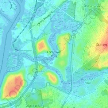
Nom : Carte topographique Freshkills Park, altitude, relief.
Altitude moyenne : 11 m
Altitude minimum : -4 m
Altitude maximum : 53 m
The initial plan was to raise the elevation of the land by filling for three years and then to redevelop it as a multi-use area with residential, recreational, and industrial components. However, three years turned into fifty years. New York City's population was growing and generating more trash and it was easy to expand the filling operation on Staten Island. The landfill accepted garbage from 1948 through 2001. By 1955, the landfill was the largest in the world. At the peak of its operation, the contents of twenty barges – each carrying 650 tons of garbage – were added to the site every day. By 1996, the mound had reached a height of 175 feet (53 m), taller than the Statue of Liberty in nearby New York Harbor. Although Staten Islanders had tried many times to close operations at the landfill, litigation efforts finally met with success that year, when regulations were passed to close the landfill by 2002. Under strong community pressure and with support of the United States Environmental Protection Agency (EPA), the landfill site was closed on March 22, 2001, but it was reopened after the September 11 attacks on the World Trade Center in Manhattan. Virtually all the materials from the World Trade Center site were sent to the temporarily reopened landfill for examination. Thousands of detectives and forensic evidence specialists worked for over 1.7 million hours at Fresh Kills Landfill to try to recover the remains of people killed in the attacks. A final count of 4,257 human remains were recovered, and more than 1,600 personal effects; the City's Chief Medical Examiner retains custody of all still-unidentified materials at a facility within the National 9/11 Memorial in Manhattan. The remaining materials at Fresh Kills were then buried in a 40-acre (160,000 m2) portion of the landfill, known as West Mound. Afterward, the landfill facility was closed permanently, in anticipation of the park on the site.
Autres cartes topographiques
Cliquez sur une carte pour visualiser sa topographie, son altitude et son relief.
Brooklyn
United States > New York > New York
Brooklyn, Kings County, New York, United States
Altitude moyenne : 9 m
Manhattan Island
United States > New York > New York
Manhattan Island, New York, United States
Altitude moyenne : 17 m
The Bronx
United States > New York > New York
The Bronx, New York, United States
Altitude moyenne : 23 m
Staten Island
United States > New York > New York
Staten Island, Richmond County, New York, United States
Altitude moyenne : 9 m
Upper West Side
United States > New York > New York
Upper West Side, Manhattan Community Board 7, Manhattan, New York County, New York, United States
Altitude moyenne : 23 m
Mill Pond Park
United States > New York > New York
Mill Pond Park, Bronx County, The Bronx, New York, United States
Altitude moyenne : 18 m
Washington Heights
United States > New York > New York
Washington Heights, Manhattan Community Board 12, Manhattan, New York County, New York, United States
Altitude moyenne : 25 m
Starlight Park
United States > New York > New York
Starlight Park, Bronx County, The Bronx, New York, United States
Altitude moyenne : 17 m
New York County
United States > New York > New York
New York County, New York, United States
Altitude moyenne : 16 m
Fort Greene Park
United States > New York > New York
Fort Greene Park, Fort Greene, Kings County, New York, United States
Altitude moyenne : 17 m
Bronx Park
United States > New York > New York
Bronx Park, New York, United States
Altitude moyenne : 30 m
Gowanus Canal
United States > New York > New York
Gowanus Canal, Kings County, New York, United States
Altitude moyenne : 11 m
Kings County
United States > New York > New York
Kings County, New York, United States, Marine Park
Altitude moyenne : 4 m
Todt Hill
United States > New York > New York
Todt Hill, Richmond County, New York, 10304, United States
Altitude moyenne : 50 m
Flushing Meadows-Corona Park
United States > New York > New York
Flushing Meadows-Corona Park, New York, United States
Altitude moyenne : 15 m
Kissena Park
United States > New York > New York
Kissena Park, Queens County, New York, United States
Altitude moyenne : 16 m
Queens County
United States > New York > New York
Queens County, New York, United States
Altitude moyenne : 11 m
Hart Island
United States > New York > New York
Hart Island, New York, United States
Altitude moyenne : 1 m
Coney Island Creek Park
United States > New York > New York
Coney Island Creek Park, Coney Island, Kings County, New York, United States
Altitude moyenne : 2 m
Jerome Park Reservoir
United States > New York > New York
Jerome Park Reservoir, The Bronx, New York, United States
Altitude moyenne : 35 m
Bronx County
United States > New York > New York
Bronx County, The Bronx, New York, United States
Altitude moyenne : 21 m
McCarren Park
United States > New York > New York
McCarren Park, Kings County, New York, United States
Altitude moyenne : 7 m
Prospect Park
United States > New York > New York
Prospect Park, Kings County, New York, United States
Altitude moyenne : 34 m
Jamaica Bay
United States > New York > New York
Jamaica Bay, Queens, New York, 11693, United States
Altitude moyenne : 0 m
Highland Park
United States > New York > New York
Highland Park, Queens County, New York, United States
Altitude moyenne : 28 m
Todt Hill
United States > New York > New York
Todt Hill, New York, 10304, United States
Altitude moyenne : 75 m
City Island
United States > New York > New York
City Island, The Bronx, New York, 10464, United States
Altitude moyenne : 1 m
Jackie Robinson Park
United States > New York > New York
Jackie Robinson Park, Brooklyn, Kings County, New York, United States
Altitude moyenne : 22 m
Forest Park
United States > New York > New York
Forest Park, New York, United States
Altitude moyenne : 25 m
Shore Road Park
United States > New York > New York
Shore Road Park, Brooklyn, New York, United States
Altitude moyenne : 9 m
Main Street Park
United States > New York > New York
Main Street Park, Brooklyn, Kings County, New York, United States
Altitude moyenne : 11 m
Kings County
United States > New York > New York
Kings County, New York, United States
Altitude moyenne : 9 m
Arbutus Lake
United States > New York > New York
Arbutus Lake, Staten Island, New York, United States
Altitude moyenne : 9 m
Middleton Playground
United States > New York > New York
Middleton Playground, Brooklyn, Kings County, New York, United States
Altitude moyenne : 13 m
Soundview Park
United States > New York > New York
Soundview Park, New York, United States
Altitude moyenne : 6 m
Richmond County
United States > New York > New York
Richmond County, New York, United States
Altitude moyenne : 9 m