
Faire un don
Équipez-vous pour votre prochaine aventure :
En tant que Partenaire Amazon, ce site perçoit une commission sur les achats éligibles sans surcoût pour vous.
Carte topographique Highland Park
Cliquez sur la carte pour afficher l’altitude.
Faire un don
Équipez-vous pour votre prochaine aventure :
En tant que Partenaire Amazon, ce site perçoit une commission sur les achats éligibles sans surcoût pour vous.
À propos de cette carte
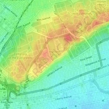
Nom : Carte topographique Highland Park, altitude, relief.
Altitude moyenne : 28 m
Altitude minimum : 6 m
Altitude maximum : 57 m
Faire un don
Équipez-vous pour votre prochaine aventure :
En tant que Partenaire Amazon, ce site perçoit une commission sur les achats éligibles sans surcoût pour vous.
Autres cartes topographiques
Cliquez sur une carte pour visualiser sa topographie, son altitude et son relief.
Queens
United States > New York > Queens County > New York
Many of the village street grids of Queens had only worded names, some were numbered according to local numbering schemes, and some had a mix of words and numbers. In the early 1920s, a "Philadelphia Plan" was instituted to overlay one numbered system upon the whole borough. The Topographical Bureau, Borough…
Altitude moyenne : 11 m
Flushing Meadows-Corona Park
United States > New York > Queens County > New York
Around 1907, contractor Michael Degnon, whose firm constructed the Williamsburg Bridge, the Cape Cod Canal, and the Steinway subway tunnel (used by today's 7 and <7> trains), purchased large tracts of marsh near Flushing Creek. At the time, the land was considered "all but worthless". Degnon envisioned…
Altitude moyenne : 15 m
Faire un don
Équipez-vous pour votre prochaine aventure :
En tant que Partenaire Amazon, ce site perçoit une commission sur les achats éligibles sans surcoût pour vous.
Queens
United States > New York > Queens County > New York
Many of the village street grids of Queens had only worded names, some were numbered according to local numbering schemes, and some had a mix of words and numbers. In the early 1920s, a "Philadelphia Plan" was instituted to overlay one numbered system upon the whole borough. The Topographical Bureau, Borough…
Altitude moyenne : 11 m