
Carte topographique Piura
Carte interactive
Cliquez sur la carte pour afficher l’altitude.
À propos de cette carte
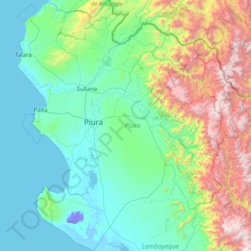
Nom : Carte topographique Piura, altitude, relief.
Lieu : Piura, Peru (-6.37209 -81.32823 -4.07933 -79.21033)
Altitude moyenne : 675 m
Altitude minimum : -25 m
Altitude maximum : 4 013 m
Topography is smooth in the coast and rough in the Sierra. There are many arid plains in the southern region. The Sechura Desert, located south of the Piura River, is Peru's largest desert and one of the world's few examples of a tropical desert; it borders a tropical terrain to the north. The Bayóvar Depression, which is the lowest point in Peru and all of the Southern Tropics, is located in this desert.
Autres cartes topographiques
Cliquez sur une carte pour visualiser sa topographie, son altitude et son relief.
Province of San Marcos
Province of San Marcos, Cajamarca, 06321, Peru
Altitude moyenne : 2 783 m
Santa Fe
Peru > Loreto > Emilio San Martín
Santa Fe, Emilio San Martín, Province of Requena, Loreto, Peru
Altitude moyenne : 103 m
Province of Lima
Peru > Lima > Lima Metropolitan Area
Province of Lima, Lima Metropolitan Area, Lima, Peru
Altitude moyenne : 1 234 m
Montevideo
Montevideo, Uranmarca, Province of Chincheros, Apurímac, Peru
Altitude moyenne : 3 249 m
Cotahuasi Subbasin Landscape Reserve
Cotahuasi Subbasin Landscape Reserve, Arequipa, Peru
Altitude moyenne : 4 390 m
Tingo Maria National Park
Peru > Huánuco > Mariano Dámaso Beraún
Tingo Maria National Park, Mariano Dámaso Beraún, Province of Leoncio Prado, Huánuco, Peru
Altitude moyenne : 1 136 m
La Rinconada
Peru > Puno > La Rinconada
La Rinconada, Province of San Antonio de Putina, Puno, Peru
Altitude moyenne : 4 646 m
Independencia
Peru > Lima > Independencia
Independencia, Province of Lima, Lima, Peru
Altitude moyenne : 224 m
Province of Pisco
Province of Pisco, Humay, Pisco, Ica, Peru
Altitude moyenne : 587 m
Fundo La Esperanza
Peru > Ica > Fundo La Esperanza
Fundo La Esperanza, Pisco, Ica, Peru
Altitude moyenne : 245 m
Villa El Salvador
Peru > Apurímac > Villa El Salvador
Villa El Salvador, Chincheros, Apurímac, Peru
Altitude moyenne : 3 644 m
Machupicchu
Peru > Cusco > Machupicchu
Machupicchu, Province of Urubamba, Cusco, Peru
Altitude moyenne : 3 640 m
Mi Perú
Peru > Constitutional Province of Callao > Mi Perú
Mi Perú, Constitutional Province of Callao, Peru
Altitude moyenne : 176 m
Pueblo Libre
Peru > San Martín > Pueblo Libre
Pueblo Libre, Moyobamba, San Martín, Peru
Altitude moyenne : 842 m
Ciudad Satélite
Peru > Junín > Ciudad Satélite
Ciudad Satélite, Province of Satipo, Junín, Peru
Altitude moyenne : 768 m
Pueblo Libre
Peru > Lima > Pueblo Libre
Pueblo Libre, Province of Lima, Lima, Peru
Altitude moyenne : 83 m
Province of Huaylas
Peru > Ancash > Santa Cruz
Province of Huaylas, Santa Cruz, Huaylas, Ancash, Peru
Altitude moyenne : 2 353 m
La Punta
Peru > Constitutional Province of Callao > La Punta
La Punta, Constitutional Province of Callao, 07021, Peru
Altitude moyenne : 4 m
Cochabamba
Peru > Apurímac > Cochabamba
Cochabamba, Chincheros, Apurímac, Peru
Altitude moyenne : 3 578 m
Province of Carhuaz
Province of Carhuaz, Marcará, Carhuaz, Ancash, Peru
Altitude moyenne : 3 217 m
Province of San Marcos
Peru > Cajamarca > José Sabogal
Province of San Marcos, José Sabogal, San Marcos, Cajamarca, Peru
Altitude moyenne : 3 865 m
Province of Caylloma
Province of Caylloma, Maca, Caylloma, Arequipa, Peru
Altitude moyenne : 4 319 m