
Carte topographique La Rinconada
Carte interactive
Cliquez sur la carte pour afficher l’altitude.
À propos de cette carte
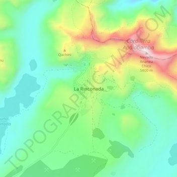
Nom : Carte topographique La Rinconada, altitude, relief.
Lieu : La Rinconada, Ananea, San Antonio de Putina, Puno, Pérou (-14.67416 -69.48688 -14.59416 -69.40688)
Altitude moyenne : 4 923 m
Altitude minimum : 4 550 m
Altitude maximum : 5 834 m
Autres cartes topographiques
Cliquez sur une carte pour visualiser sa topographie, son altitude et son relief.
Taquile
Le point culminant de l’île se situe à 4 050 mètres d'altitude, et son village principal est à 3 950 mètres d’altitude. On trouve des ruines pré-Incas sur la partie la plus haute de l’île, ainsi que des terrasses agricoles sur les coteaux. Depuis les hauteurs de Taquile, on a une vue sur les…
Altitude moyenne : 3 829 m
Lac Titicaca (secteur péruvien)
Le lac Titicaca, situé dans la cordillère des Andes, est traversé par la frontière entre la Bolivie et le Pérou. C'est le plus grand lac d’eau douce d'Amérique du Sud en volume d'eau et en longueur, mais pas en superficie (le lac Maracaibo couvre une superficie de plus de 13 000 km2). Il est aussi…
Altitude moyenne : 4 012 m
Lac Titicaca
Le lac Titicaca, situé dans la cordillère des Andes, est traversé par la frontière entre la Bolivie et le Pérou. C'est le plus grand lac d'Amérique du Sud en volume d'eau et en longueur, mais pas en superficie (le lac Maracaibo couvre une superficie de plus de 13 000 km2). Il est aussi considéré comme…
Altitude moyenne : 3 870 m
Lac Titicaca
Le lac Titicaca, situé dans la cordillère des Andes, est traversé par la frontière entre la Bolivie et le Pérou. C'est le plus grand lac d’eau douce d'Amérique du Sud en volume d'eau et en longueur, mais pas en superficie (le lac Maracaibo couvre une superficie de plus de 13 000 km2). Il est aussi…
Altitude moyenne : 3 870 m
Taquile
Le point culminant de l’île se situe à 4 050 mètres d'altitude, et son village principal est à 3 950 mètres d’altitude. On trouve des ruines pré-Incas sur la partie la plus haute de l’île, ainsi que des terrasses agricoles sur les coteaux. Depuis les hauteurs de Taquile, on a une vue sur les…
Altitude moyenne : 3 829 m