
Carte topographique Stevensweert
Carte interactive
Cliquez sur la carte pour afficher l’altitude.
À propos de cette carte
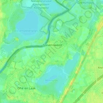
Nom : Carte topographique Stevensweert, altitude, relief.
Lieu : Stevensweert, Maasgouw, Limburg, Nederland (51.10911 5.81870 51.14833 5.87272)
Altitude moyenne : 25 m
Altitude minimum : 17 m
Altitude maximum : 36 m
De hoogte van Stevensweert bedraagt ongeveer 23 meter.
Autres cartes topographiques
Cliquez sur une carte pour visualiser sa topographie, son altitude et son relief.
Bilt
Nederland > Limburg > Stevensweert
Bilt, Stevensweert, Maasgouw, Limburg, Nederland, 6107 BM, Nederland
Altitude moyenne : 25 m