
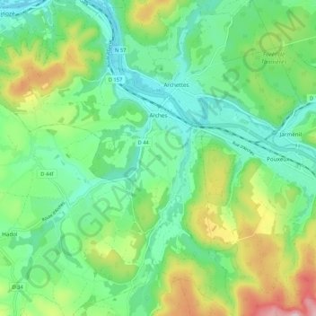
Carte topographique Arches
Carte interactive
Cliquez sur la carte pour afficher l’altitude.
À propos de cette carte
Nom : Carte topographique Arches, altitude, relief.
Altitude moyenne : 414 m
Altitude minimum : 332 m
Altitude maximum : 598 m
Autres cartes topographiques
Cliquez sur une carte pour visualiser sa topographie, son altitude et son relief.
Saint-Remy
Saint-Remy, Saint-Dié-des-Vosges, Vosges, Grand Est, Metropolitan France, 88480, France
Altitude moyenne : 363 m
Harchéchamp
Harchéchamp, Neufchâteau, Vosges, Grand Est, Metropolitan France, 88300, France
Altitude moyenne : 348 m
Blevaincourt
Blevaincourt, Neufchâteau, Vosges, Grand Est, Metropolitan France, 88320, France
Altitude moyenne : 361 m
Le Chêne
France > Grand Est > Vosges > Rupt-sur-Moselle
Le Chêne, Rupt-sur-Moselle, Épinal, Vosges, Grand Est, Metropolitan France, 88360, France
Altitude moyenne : 576 m
Mont-lès-Neufchâteau
Mont-lès-Neufchâteau, Neufchâteau, Vosges, Grand Est, Metropolitan France, 88300, France
Altitude moyenne : 341 m
La Mergerie
France > Grand Est > Vosges > Chef-Haut
La Mergerie, Chef-Haut, Épinal, Vosges, Grand Est, Metropolitan France, 88500, France
Altitude moyenne : 360 m
Le Thillot
Le Thillot, Épinal, Vosges, Grand Est, Metropolitan France, 88160, France
Altitude moyenne : 623 m
Neufchâteau
Neufchâteau, Vosges, Grand Est, Metropolitan France, 88300, France
Altitude moyenne : 334 m
Nayemont
France > Grand Est > Vosges > Ban-de-Sapt
Nayemont, Ban-de-Sapt, Saint-Dié-des-Vosges, Vosges, Grand Est, Metropolitan France, 88210, France
Altitude moyenne : 604 m
La Croix Ferry
France > Grand Est > Vosges > Le Tholy > Le Rain Brice
La Croix Ferry, Le Rain Brice, Le Tholy, Saint-Dié-des-Vosges, Vosges, Grand Est, Metropolitan France, 88530, France
Altitude moyenne : 659 m
Raon-l'Étape
Raon-l'Étape, Saint-Dié-des-Vosges, Vosges, Grand Est, Metropolitan France, 88110, France
Altitude moyenne : 362 m
Rupt-sur-Moselle
France > Grand Est > Vosges > Rupt-sur-Moselle
Rupt-sur-Moselle, Épinal, Vosges, Grand Est, Metropolitan France, 88360, France
Altitude moyenne : 637 m
Plombières-les-Bains
Plombières-les-Bains, Épinal, Vosges, Grand Est, Metropolitan France, 88370, France
Altitude moyenne : 516 m
Les Poulières
France > Grand Est > Vosges > Les Poulières
Les Poulières, Saint-Dié-des-Vosges, Vosges, Grand Est, Metropolitan France, 88600, France
Altitude moyenne : 510 m
Colroy-la-Grande
France > Grand Est > Vosges > Provenchères-et-Colroy
Colroy-la-Grande, Provenchères-et-Colroy, Saint-Dié-des-Vosges, Vosges, Grand Est, Metropolitan France, 88490, France
Altitude moyenne : 516 m
Bettegney-Saint-Brice
France > Grand Est > Vosges > Bettegney-Saint-Brice
Bettegney-Saint-Brice, Épinal, Vosges, Grand Est, Metropolitan France, 88450, France
Altitude moyenne : 349 m
Laveline-devant-Bruyères
France > Grand Est > Vosges > Laveline-devant-Bruyères
Laveline-devant-Bruyères, Épinal, Vosges, Grand Est, Metropolitan France, 88600, France
Altitude moyenne : 492 m
Saint-Maurice-sur-Moselle
France > Grand Est > Vosges > Saint-Maurice-sur-Moselle
Saint-Maurice-sur-Moselle, Épinal, Vosges, Grand Est, Metropolitan France, 88560, France
Altitude moyenne : 815 m
Plainfaing
Plainfaing, Saint-Dié-des-Vosges, Vosges, Grand Est, Metropolitan France, 88230, France
Altitude moyenne : 815 m
Basse-sur-le-Rupt
France > Grand Est > Vosges > Basse-sur-le-Rupt
Basse-sur-le-Rupt, Saint-Dié-des-Vosges, Vosges, Grand Est, Metropolitan France, 88120, France
Altitude moyenne : 677 m
Schlitte Mountain
France > Grand Est > Vosges > La Bresse
Schlitte Mountain, Route de Vologne, La Bresse, Saint-Dié-des-Vosges, Vosges, Grand Est, Metropolitan France, 88250, France
Altitude moyenne : 1 032 m
Ollainville
Ollainville, Neufchâteau, Vosges, Grand Est, Metropolitan France, 88170, France
Altitude moyenne : 354 m
Bellefontaine
Bellefontaine, Épinal, Vosges, Grand Est, Metropolitan France, 88370, France
Altitude moyenne : 544 m