
Carte topographique Les Poulières
Carte interactive
Cliquez sur la carte pour afficher l’altitude.
Les Poulières
La commune des Poulières est située dans la vallée du Neuné, affluent droit de la Vologne, entre Biffontaine, à l'est, et La Chapelle-devant-Bruyères, au sud et à l'ouest. Le Col de l'Arnelle, à 624 mètres d'altitude, est un passage forestier vers la troisième commune limitrophe, au nord-ouest : Belmont-sur-Buttant.
À propos de cette carte
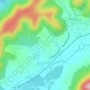
Nom : Carte topographique Les Poulières, altitude, relief.
Altitude moyenne : 510 m
Altitude minimum : 438 m
Altitude maximum : 709 m
Autres cartes topographiques
Cliquez sur une carte pour visualiser sa topographie, son altitude et son relief.
Le Haut du Tôt
France > Grand Est > Vosges > Sapois
Perché à 827 m d'altitude dans le massif des Vosges sur le versant nord de la vallée de la Moselotte, le Haut du Tôt est la plus haute paroisse du département des Vosges. Il ne constitue cependant pas une commune, ayant été partagé arbitrairement par une ligne nord-sud entre Vagney et Sapois.
Altitude moyenne : 746 m
Réserve naturelle de la Tourbière de Machais
France > Grand Est > Vosges > Le Régit
Altitude moyenne : 997 m
Le Grand Ventron
France > Grand Est > Vosges > Ventron
Le Grand Ventron est un sommet du massif des Vosges culminant à 1 204 m d'altitude. Il est partagé entre Ventron et Cornimont du côté lorrain et Kruth du côté alsacien. Plus au sud se trouve le Petit Ventron qui culmine à 1 155 mètres d'altitude.
Altitude moyenne : 1 002 m
Château d'Épinal
France > Grand Est > Vosges > Épinal
Le château d'Épinal et les ruines de l'ancienne forteresse dominent la ville d'Épinal et la vallée de la Moselle à 387 m d'altitude.
Altitude moyenne : 368 m