
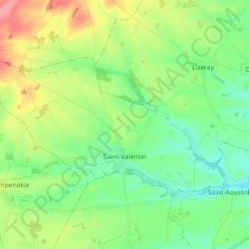
Carte topographique Saint-Valentin
Carte interactive
Cliquez sur la carte pour afficher l’altitude.
À propos de cette carte
Nom : Carte topographique Saint-Valentin, altitude, relief.
Altitude moyenne : 164 m
Altitude minimum : 137 m
Altitude maximum : 217 m
Autres cartes topographiques
Cliquez sur une carte pour visualiser sa topographie, son altitude et son relief.
Le Blanc
France > Centre-Val de Loire > Indre
Le Blanc, Indre, Centre-Val de Loire, France métropolitaine, 36300, France
Altitude moyenne : 111 m
Buzançais
France > Centre-Val de Loire > Indre
Buzançais, Châteauroux, Indre, Centre-Val de Loire, France métropolitaine, 36500, France
Altitude moyenne : 130 m
Sainte-Sévère-sur-Indre
France > Centre-Val de Loire > Indre > Sainte-Sévère-sur-Indre
Sainte-Sévère-sur-Indre, La Châtre, Indre, Centre-Val de Loire, France métropolitaine, 36160, France
Altitude moyenne : 287 m
Saint-Christophe-en-Boucherie
France > Centre-Val de Loire > Indre > Saint-Christophe-en-Boucherie
Saint-Christophe-en-Boucherie, La Châtre, Indre, Centre-Val de Loire, France métropolitaine, 36400, France
Altitude moyenne : 237 m
Issoudun
France > Centre-Val de Loire > Indre > Issoudun
Issoudun, Indre, Centre-Val de Loire, France métropolitaine, 36100, France
Altitude moyenne : 149 m
Châteauroux
France > Centre-Val de Loire > Indre > Châteauroux
Châteauroux, Indre, Centre-Val de Loire, France métropolitaine, 36000, France
Altitude moyenne : 153 m
Éguzon-Chantôme
France > Centre-Val de Loire > Indre
Éguzon-Chantôme, Châteauroux, Indre, Centre-Val de Loire, France métropolitaine, 36270, France
Altitude moyenne : 264 m