
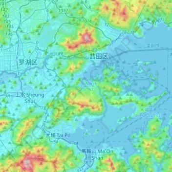
Carte topographique 北區 North District
Carte interactive
Cliquez sur la carte pour afficher l’altitude.
À propos de cette carte
Nom : Carte topographique 北區 North District, altitude, relief.
Lieu : 北區 North District, New Territories, Hongkong, China (22.46568 114.07833 22.56833 114.33618)
Altitude moyenne : 115 m
Altitude minimum : -4 m
Altitude maximum : 946 m
Autres cartes topographiques
Cliquez sur une carte pour visualiser sa topographie, son altitude et son relief.
扯旗山 Victoria Peak
China > Hongkong > Hong Kong Island
扯旗山 Victoria Peak, Hong Kong Island, Hongkong, China
Altitude moyenne : 209 m
Victoria Peak Lookout (over the Victoria Harbour)
China > Hongkong > Hong Kong Island
Victoria Peak Lookout (over the Victoria Harbour), 盧吉道 Lugard Road, 太平山 Victoria Peak, 山頂 The Peak, 中西區 Central and Western District, Hong Kong Island, Hongkong, China
Altitude moyenne : 191 m
Southern District
China > Hongkong > Hong Kong Island
Southern District, Hong Kong Island, Hongkong, China
Altitude moyenne : 36 m
維多利亞港 Victoria Harbour
China > Hongkong > 葵青區 Kwai Tsing District
維多利亞港 Victoria Harbour, 葵青區 Kwai Tsing District, New Territories, Hongkong, China
Altitude moyenne : 74 m
中區 Central District
China > Hongkong > Hong Kong Island
中區 Central District, Hong Kong Island, Hongkong, China
Altitude moyenne : 114 m
上徑口 Sheung Keng Hau
China > Hongkong > 沙田區 Sha Tin District > 上徑口 Sheung Keng Hau
上徑口 Sheung Keng Hau, 沙田區 Sha Tin District, New Territories, Hongkong, China
Altitude moyenne : 147 m
Tai Mo Shan
China > Hongkong > 荃灣區 Tsuen Wan District
Tai Mo Shan, 荃灣區 Tsuen Wan District, New Territories, Hongkong, China
Altitude moyenne : 600 m