
Carte topographique 中區 Central District
Carte interactive
Cliquez sur la carte pour afficher l’altitude.
À propos de cette carte
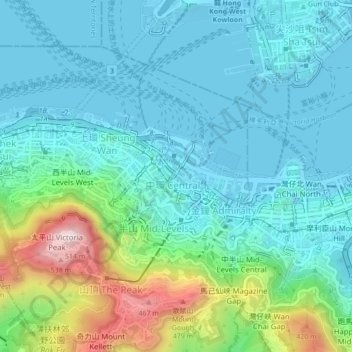
Nom : Carte topographique 中區 Central District, altitude, relief.
Lieu : 中區 Central District, Hong Kong Island, Hongkong, China (22.26274 114.13871 22.30274 114.17871)
Altitude moyenne : 114 m
Altitude minimum : -4 m
Altitude maximum : 534 m
Autres cartes topographiques
Cliquez sur une carte pour visualiser sa topographie, son altitude et son relief.
扯旗山 Victoria Peak
China > Hongkong > Hong Kong Island
扯旗山 Victoria Peak, Hong Kong Island, Hongkong, China
Altitude moyenne : 209 m
Victoria Peak Lookout (over the Victoria Harbour)
China > Hongkong > Hong Kong Island
Victoria Peak Lookout (over the Victoria Harbour), 盧吉道 Lugard Road, 太平山 Victoria Peak, 山頂 The Peak, 中西區 Central and Western District, Hong Kong Island, Hongkong, China
Altitude moyenne : 191 m
Southern District
China > Hongkong > Hong Kong Island
Southern District, Hong Kong Island, Hongkong, China
Altitude moyenne : 36 m