
Carte topographique Skogafoss
Carte interactive
Cliquez sur la carte pour afficher l’altitude.
À propos de cette carte
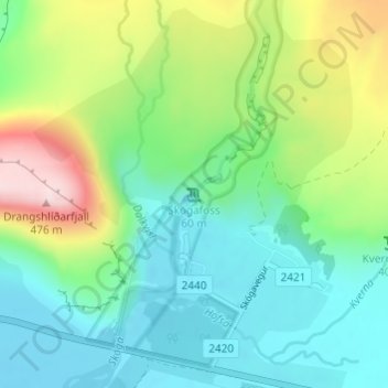
Nom : Carte topographique Skogafoss, altitude, relief.
Lieu : Skogafoss, Rangárþing eystra, Southern Region, Iceland (63.53205 -19.51134 63.53215 -19.51124)
Altitude moyenne : 145 m
Altitude minimum : 17 m
Altitude maximum : 459 m
Autres cartes topographiques
Cliquez sur une carte pour visualiser sa topographie, son altitude et son relief.
Eyjafjallajökull
Eyjafjallajökull, Rangárþing eystra, Southern Region, Iceland
Altitude moyenne : 1 459 m
Eyjafjallajökull
Eyjafjallajökull, Rangárþing eystra, Southern Region, Iceland
Altitude moyenne : 821 m