
Carte topographique Eyjafjallajökull
Carte interactive
Cliquez sur la carte pour afficher l’altitude.
Eyjafjallajökull
Eyjafjallajökull (Icelandic: [ˈeiːjaˌfjat͡ɬaˌjœːkʏt͡ɬ] ; lit. 'glacier of the mountains of the islands'), sometimes referred to by the numeronym E15, is one of the smaller ice caps of Iceland, north of Skógar and west of Mýrdalsjökull. The ice cap covers the caldera of a volcano with a summit elevation of 1,651 metres (5,417 ft). The volcano has erupted relatively frequently since the Last Glacial Period, most recently in 2010, when, although relatively small for a volcanic eruption, it caused enormous disruption to air travel across northern and western Europe for a week.
À propos de cette carte
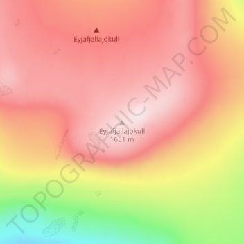
Nom : Carte topographique Eyjafjallajökull, altitude, relief.
Altitude moyenne : 1 459 m
Altitude minimum : 1 162 m
Altitude maximum : 1 628 m
Autres cartes topographiques
Cliquez sur une carte pour visualiser sa topographie, son altitude et son relief.
Eyjafjallajökull
Eyjafjallajökull (Icelandic: (listen); lit. 'glacier of the mountains of the islands') is one of the smaller ice caps of Iceland, north of Skógar and west of Mýrdalsjökull. The ice cap covers the caldera of a volcano with a summit elevation of 1,651 metres (5,417 ft). The volcano has erupted relatively…
Altitude moyenne : 819 m