
Carte topographique Long Thành District
Carte interactive
Cliquez sur la carte pour afficher l’altitude.
À propos de cette carte
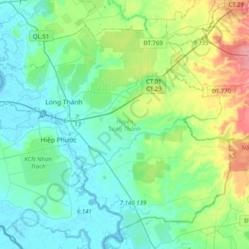
Nom : Carte topographique Long Thành District, altitude, relief.
Lieu : Long Thành District, Dong Nai province, 8464, Vietnam (10.64365 106.86427 10.87867 107.14637)
Altitude moyenne : 41 m
Altitude minimum : -3 m
Altitude maximum : 170 m
Autres cartes topographiques
Cliquez sur une carte pour visualiser sa topographie, son altitude et son relief.
An Phuoc
Vietnam > Dong Nai province > Long Thành District
An Phuoc, Long Thành District, Đồng Nai Province, Vietnam
Altitude moyenne : 22 m