Géolocaliser

Carte topographique Meenangadi

Cliquez sur la carte pour afficher l’altitude.

À propos de cette carte

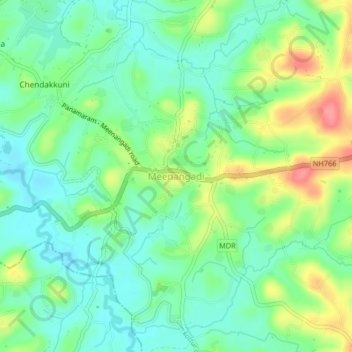
Nom : Carte topographique Meenangadi, altitude, relief.

Lieu : Meenangadi, Sulthanbathery, Wayanad, Kerala, 673591, India (11.63947 76.14684 11.67947 76.18684)

Altitude moyenne : 760 m

Altitude minimum : 731 m

Altitude maximum : 815 m

Autres cartes topographiques

Cliquez sur une carte pour visualiser sa topographie, son altitude et son relief.

Kuruva Island

India > Kerala > Sulthanbathery

Altitude moyenne : 733 m

Kenichira

India > Kerala > Sulthanbathery

Altitude moyenne : 788 m

Sulthan Bathery

India > Kerala > Sulthanbathery > Sultan Bathery

Altitude moyenne : 873 m

Marakavu

India > Kerala > Sulthanbathery > Pulpally

Altitude moyenne : 769 m

Nellarachal

India > Kerala > Sulthanbathery

Altitude moyenne : 781 m

Vadakkanad

India > Kerala > Sulthanbathery

Altitude moyenne : 896 m

Edakkal

India > Kerala > Sulthanbathery > Ambalavayal

Altitude moyenne : 927 m

Kalluvayal

India > Kerala > Sulthanbathery > Pulpally

Altitude moyenne : 816 m

Seethamount

India > Kerala > Sulthanbathery > Kabanigiri

Altitude moyenne : 731 m

Sulthan Bathery

India > Kerala > Sulthanbathery > Sultan Bathery

Altitude moyenne : 873 m

Équipez-vous pour votre prochaine aventure :

🧢Chapeau de soleil à large bord - Protection complète du visage et de la nuque
🎒Poche à eau pour sac à dos - Hydratation facile sans s'arrêter de marcher
🎒Sac d'hydratation pour cyclisme - Compact pour les sorties rapides en VTT
🩹Trousse de premiers soins de secours - Compacte et complète pour les blessures légères en sentier
🧥Doudoune compressible - Chaleur instantanée pour les pauses au sommet

En tant que Partenaire Amazon, ce site perçoit une commission sur les achats éligibles sans surcoût pour vous.