
Carte topographique Phúc Yên
Carte interactive
Cliquez sur la carte pour afficher l’altitude.
À propos de cette carte
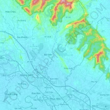
Nom : Carte topographique Phúc Yên, altitude, relief.
Lieu : Phúc Yên, Vinh Phuc Province, 84211, Vietnam (21.21248 105.68046 21.41623 105.79290)
Altitude moyenne : 49 m
Altitude minimum : 4 m
Altitude maximum : 518 m
Autres cartes topographiques
Cliquez sur une carte pour visualiser sa topographie, son altitude et son relief.
Thanh Lãng
Vietnam > Vinh Phuc Province > Bình Xuyên District
Thanh Lãng, Bình Xuyên District, Vĩnh Phúc Province, Vietnam
Altitude moyenne : 10 m
Tam Đảo District
Tam Đảo District, Vinh Phuc Province, Vietnam
Altitude moyenne : 213 m
Đồng Xuân
Vietnam > Vinh Phuc Province > Phúc Yên
Đồng Xuân, Phúc Yên, Vĩnh Phúc Province, Vietnam
Altitude moyenne : 22 m