
Carte topographique Sikkim
Carte interactive
Cliquez sur la carte pour afficher l’altitude.
À propos de cette carte
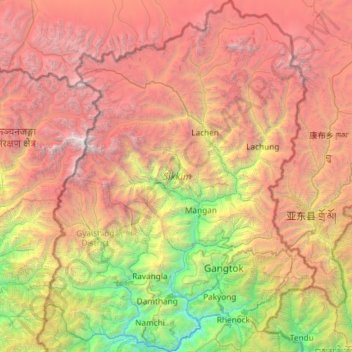
Nom : Carte topographique Sikkim, altitude, relief.
Lieu : Sikkim, India (27.07940 88.01203 28.12264 88.92137)
Altitude moyenne : 3 786 m
Altitude minimum : 264 m
Altitude maximum : 8 447 m
Situated in the Himalayan mountains, the state of Sikkim is characterised by mountainous terrain. Almost the entire state is hilly, with an elevation ranging from 280 metres (920 ft) in the south at the border with West Bengal to 8,586 metres (28,169 ft) in northern peaks near Nepal and Tibet. The summit of Kangchenjunga, the world's third-highest peak, is the state's highest point, situated on the border between Sikkim and Nepal. For the most part, the land is unfit for agriculture because of the rocky, precipitous slopes. However, some hill slopes have been converted into terrace farms.
Autres cartes topographiques
Cliquez sur une carte pour visualiser sa topographie, son altitude et son relief.
Bangalore East
Bangalore East, Bengaluru Urban, Karnataka, India
Altitude moyenne : 889 m
Coimbatore
India > Tamil Nadu > Coimbatore North
Coimbatore, Coimbatore North, Coimbatore District, Tamil Nadu, 641001, India
Altitude moyenne : 452 m
Lucknow
India > Uttar Pradesh > Lucknow
Lucknow, Lucknow District, Uttar Pradesh, 226027, India
Altitude moyenne : 120 m
Dharamshala
India > Himachal Pradesh > Dharamshala
Dharamshala, Kangra District, Himachal Pradesh, 176200, India
Altitude moyenne : 1 781 m
Mohali
India > Madhya Pradesh > Rehli Tahsil
Mohali, Rehli Tahsil, Sagar District, Madhya Pradesh, India
Altitude moyenne : 430 m
Dharav Parav
India > Madhya Pradesh > Bankhedi Tahsil
Dharav Parav, Bankhedi Tahsil, Narmadapuram District, Madhya Pradesh, India
Altitude moyenne : 378 m
Kashipur
India > Uttarakhand > Kashipur
Kashipur, Udham Singh Nagar District, Uttarakhand, 244713, India
Altitude moyenne : 233 m
Bhagsu
India > Himachal Pradesh > Dharamshala
Bhagsu, Dharamshala, Kangra District, Himachal Pradesh, 176219, India
Altitude moyenne : 1 955 m
Tholpetty
India > Kerala > Mananthavady
Tholpetty, Mananthavady, Wayanad District, Kerala, 571250, India
Altitude moyenne : 875 m
Rampura
India > Gujarat > Detroj Rampura Taluka
Rampura, Detroj Rampura Taluka, Ahmedabad District, Gujarat, 382140, India
Altitude moyenne : 42 m
Dantiwada dam
India > Gujarat > Dantiwada Taluka > Dantiwada
Dantiwada dam, Dantiwada, Dantiwada Taluka, Banaskantha District, Gujarat, 385505, India
Altitude moyenne : 170 m
Gullah
India > Punjab > Guruharsahai Tahsil
Gullah, Guruharsahai Tahsil, Firozpur District, Punjab, 152024, India
Altitude moyenne : 187 m
Machilipatnam
India > Andhra Pradesh > Machilipatnam
Machilipatnam, Krishna, Andhra Pradesh, 521001, India
Altitude moyenne : 4 m
Thrikkunnapuzha
India > Kerala > Karthikappally
Thrikkunnapuzha, Karthikappally, Alappuzha District, Kerala, 690516, India
Altitude moyenne : 2 m
Jaipur
India > Rajasthan > Jaipur Tehsil
Jaipur, Jaipur Municipal Corporation, Jaipur Tehsil, Jaipur, Rajasthan, 302001, India
Altitude moyenne : 408 m
Maranda
India > Madhya Pradesh > Baihar Tahsil
Maranda, Baihar Tahsil, Balaghat District, Madhya Pradesh, India
Altitude moyenne : 641 m
Waruda
India > Maharashtra > Teosa
Waruda, Teosa, Amravati, Maharashtra, India
Altitude moyenne : 335 m
Mundi
India > Madhya Pradesh > Damoh Tahsil
Mundi, Damoh Tahsil, Damoh District, Madhya Pradesh, India
Altitude moyenne : 364 m
Galore
Galore, Hamirpur District, Himachal Pradesh, 177006, India
Altitude moyenne : 693 m
Suryapet
India > Telangana > Suryapet mandal
Suryapet, Suryapet mandal, Suryapet District, Telangana, 508213, India
Altitude moyenne : 180 m
Vallapuzha
Vallapuzha, Pattambi, Palakkad District, Kerala, 679335, India
Altitude moyenne : 56 m
Jaynagar - I
Jaynagar - I, South 24 Parganas District, West Bengal, India
Altitude moyenne : 4 m
Bargara
India > Madhya Pradesh > Chitrangi Tahsil
Bargara, Chitrangi Tahsil, Singrauli District, Madhya Pradesh, India
Altitude moyenne : 211 m
Kerla
India > Rajasthan > Pali Tehsil
Kerla, Pali Tehsil, Pali District, Rajasthan, India
Altitude moyenne : 199 m
Rajkot
India > Gujarat > Rajkot East Taluka
Rajkot, Rajkot East Taluka, Rajkot District, Gujarat, 360001, India
Altitude moyenne : 141 m
Bering
India > Punjab > Mukerian Tahsil
Bering, Mukerian Tahsil, Hoshiarpur District, Punjab, 144223, India
Altitude moyenne : 622 m
Papan
India > Madhya Pradesh > Seoni-Malwa Tahsil
Papan, Seoni-Malwa Tahsil, Narmadapuram District, Madhya Pradesh, India
Altitude moyenne : 281 m
Puducherry
India > Puducherry > Puducherry Taluk
Puducherry, Puducherry Taluk, Puducherry District, Puducherry, 605001, India
Altitude moyenne : 10 m
Malak
India > Punjab > Kharar Tahsil
Malak, Kharar Tahsil, Sahibzada Ajit Singh Nagar District, Punjab, 140901, India
Altitude moyenne : 352 m
Tharwa
India > Madhya Pradesh > Harrai Tahsil
Tharwa, Harrai Tahsil, Chhindwara District, Madhya Pradesh, India
Altitude moyenne : 644 m
Sukma
India > Chhattisgarh > Sukma Tahsil
Sukma, Sukma Tahsil, Sukma District, Chhattisgarh, 494111, India
Altitude moyenne : 219 m
Sullurpeta
India > Andhra Pradesh > Sullurpeta
Sullurpeta, Tirupati District, Andhra Pradesh, 524121, India
Altitude moyenne : 4 m
Para River
India > Haryana > Siwan > KACHI PISOL
Para River, KACHI PISOL, Siwan, Kaithal District, Haryana, 136033, India
Altitude moyenne : 235 m
Thiruvallur
Thiruvallur, Thiruvallur District, Tamil Nadu, India
Altitude moyenne : 50 m