
Carte topographique Gangtok
Carte interactive
Cliquez sur la carte pour afficher l’altitude.
À propos de cette carte
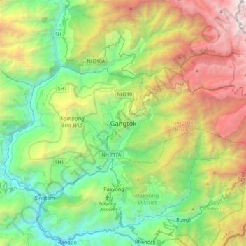
Nom : Carte topographique Gangtok, altitude, relief.
Lieu : Gangtok, Gangtok District, Sikkim, 737101, India (27.16905 88.45227 27.48905 88.77227)
Altitude moyenne : 1 911 m
Altitude minimum : 283 m
Altitude maximum : 5 193 m
Gangtok (Sikkimese: [ɡaŋt̪ʰòk]) is a city, municipality, the capital and the most populous city of the Indian state of Sikkim and also the headquarters of Gangtok District. Gangtok is in the eastern Himalayan range, at an elevation of 1,650 m (5,410 ft). The city's population of 100,000 consists of the three Sikkimese ethnicities the Bhutias, Lepchas, Gorkhalis and also plainsmen from other states of India have settled here. Within the higher peaks of the Himalayas and with a year-round mild temperate climate, Gangtok is at the centre of Sikkim's tourism industry.
Autres cartes topographiques
Cliquez sur une carte pour visualiser sa topographie, son altitude et son relief.
Western Sikkim Subsection
India > Sikkim > Chungthang
Western Sikkim Subsection, Chungthang, Mangan District, Sikkim, 737120, India
Altitude moyenne : 3 896 m
West District
West District, West Sikkim District, Sikkim, 737111, India
Altitude moyenne : 2 636 m
Zemu Glacier
Zemu Glacier, Chungthang, North Sikkim District, Sikkim, India
Altitude moyenne : 5 499 m