Géolocaliser

Carte topographique Muthanga

Cliquez sur la carte pour afficher l’altitude.

À propos de cette carte

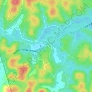
Nom : Carte topographique Muthanga, altitude, relief.

Lieu : Muthanga, Sulthanbathery, Wayanad, Kerala, India (11.65145 76.34191 11.69145 76.38191)

Altitude moyenne : 866 m

Altitude minimum : 841 m

Altitude maximum : 910 m

Autres cartes topographiques

Cliquez sur une carte pour visualiser sa topographie, son altitude et son relief.

Vadakkanad

India > Kerala > Sulthanbathery

Altitude moyenne : 896 m

Kuruva Island

India > Kerala > Sulthanbathery

Altitude moyenne : 733 m

Kenichira

India > Kerala > Sulthanbathery

Altitude moyenne : 788 m

Sulthan Bathery

India > Kerala > Sulthanbathery > Sultan Bathery

Altitude moyenne : 873 m

Marakavu

India > Kerala > Sulthanbathery > Pulpally

Altitude moyenne : 769 m

Nellarachal

India > Kerala > Sulthanbathery

Altitude moyenne : 781 m

Edakkal

India > Kerala > Sulthanbathery > Ambalavayal

Altitude moyenne : 927 m

Kalluvayal

India > Kerala > Sulthanbathery > Pulpally

Altitude moyenne : 816 m

Seethamount

India > Kerala > Sulthanbathery > Kabanigiri

Altitude moyenne : 731 m

Sulthan Bathery

India > Kerala > Sulthanbathery > Sultan Bathery

Altitude moyenne : 873 m

Équipez-vous pour votre prochaine aventure :

🛠️Outil multi-usage pour vélo - Réparations rapides lors d'exploration de sentiers reculés
🍼Bouteille d'eau isotherme 1L - Maintient l'eau fraîche ou le thé chaud pendant des heures
🧗Équipement alpinisme - Matériel pour terrains exigeants
🩳Pantalons de randonnée - Pantalons résistants et confortables
🧭Boussoles de navigation - Boussoles fiables pour orientation et cartographie

En tant que Partenaire Amazon, ce site perçoit une commission sur les achats éligibles sans surcoût pour vous.