
Carte topographique New Haven County
Carte interactive
Cliquez sur la carte pour afficher l’altitude.
À propos de cette carte
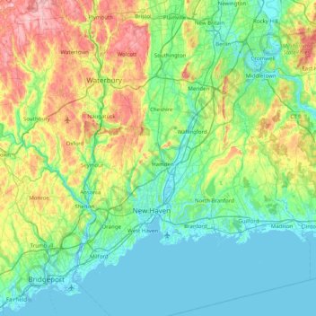
Nom : Carte topographique New Haven County, altitude, relief.
Altitude moyenne : 89 m
Altitude minimum : -4 m
Altitude maximum : 385 m
The terrain is mostly flat near the coast, with low hills defining the rest of the area, rising significantly only in the north of the county. The highest elevation is close to the northernmost point in the county, found at two areas of approximately 1,050 feet (320 m) above sea level in the town of Wolcott. The lowest point is sea level.
Autres cartes topographiques
Cliquez sur une carte pour visualiser sa topographie, son altitude et son relief.
Guilford
United States > Connecticut > South Central Connecticut Planning Region
Guilford, South Central Connecticut Planning Region, Connecticut, United States
Altitude moyenne : 62 m
Sleeping Giant State Park
United States > Connecticut > South Central Connecticut Planning Region > Hamden
Sleeping Giant State Park, Hamden, South Central Connecticut Planning Region, Connecticut, United States
Altitude moyenne : 79 m
Lake Whitney
United States > Connecticut > South Central Connecticut Planning Region > Hamden
Lake Whitney, Hamden, South Central Connecticut Planning Region, Connecticut, United States
Altitude moyenne : 25 m
North Branford Town Green
United States > Connecticut > South Central Connecticut Planning Region > North Branford
North Branford Town Green, North Branford, South Central Connecticut Planning Region, Connecticut, United States
Altitude moyenne : 44 m
New Haven
United States > Connecticut > South Central Connecticut Planning Region
New Haven, South Central Connecticut Planning Region, Connecticut, United States
Altitude moyenne : 20 m
Branford
United States > Connecticut > South Central Connecticut Planning Region
Branford, South Central Connecticut Planning Region, Connecticut, 06405, United States
Altitude moyenne : 17 m
Hamden
United States > Connecticut > South Central Connecticut Planning Region
Hamden, South Central Connecticut Planning Region, Connecticut, United States
Altitude moyenne : 64 m
Milford
United States > Connecticut > South Central Connecticut Planning Region
Milford, South Central Connecticut Planning Region, Connecticut, United States
Altitude moyenne : 17 m
Meriden
United States > Connecticut > South Central Connecticut Planning Region
Meriden, South Central Connecticut Planning Region, Connecticut, United States
Altitude moyenne : 92 m
Meriden
United States > Connecticut > South Central Connecticut Planning Region
Meriden, South Central Connecticut Planning Region, Connecticut, United States
Altitude moyenne : 88 m
Madison
United States > Connecticut > South Central Connecticut Planning Region
Madison, South Central Connecticut Planning Region, Connecticut, 06443, United States
Altitude moyenne : 69 m