
Carte topographique Sleeping Giant State Park
Carte interactive
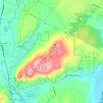
Cliquez sur la carte pour afficher l’altitude.
À propos de cette carte
Nom : Carte topographique Sleeping Giant State Park, altitude, relief.
Altitude moyenne : 79 m
Altitude minimum : 5 m
Altitude maximum : 215 m
Sleeping Giant (also known as the Blue Hills and Mount Carmel), (Hobbomock in Quinnipiac), is a rugged traprock mountain with a high point of 739 feet (225 m), located eight miles (13 km) north of New Haven, Connecticut. A prominent landscape feature visible for miles, the Sleeping Giant receives its name from its anthropomorphic resemblance to a slumbering human figure as seen from either the north or south. The Giant is known for its expansive clifftop vistas, rugged topography, and microclimate ecosystems. Most of the Giant is located within Sleeping Giant State Park. The mountain is a popular recreation site: over 30 miles (48 km) of hiking trails traverse it including 5 miles (8 km) of the 23-mile (37 km) Quinnipiac Trail. Quinnipiac University is located at Mount Carmel's foot in Hamden.
Autres cartes topographiques
Cliquez sur une carte pour visualiser sa topographie, son altitude et son relief.
Lake Whitney
United States > Connecticut > South Central Connecticut Planning Region > Hamden
Lake Whitney, Hamden, South Central Connecticut Planning Region, Connecticut, United States
Altitude moyenne : 25 m