
Carte topographique Hawley
Carte interactive
Cliquez sur la carte pour afficher l’altitude.
À propos de cette carte
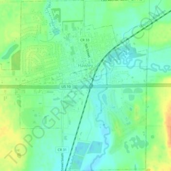
Nom : Carte topographique Hawley, altitude, relief.
Lieu : Hawley, Clay County, Minnesota, United States (46.86273 -96.33989 46.89189 -96.30134)
Altitude moyenne : 356 m
Altitude minimum : 343 m
Altitude maximum : 377 m
Autres cartes topographiques
Cliquez sur une carte pour visualiser sa topographie, son altitude et son relief.
Dilworth
United States > Minnesota > Clay County
Dilworth, Clay County, Minnesota, 56529, United States
Altitude moyenne : 278 m
Comstock
United States > Minnesota > Clay County
Comstock, Clay County, Minnesota, 56525, United States
Altitude moyenne : 281 m
Hitterdal
United States > Minnesota > Clay County
Hitterdal, Clay County, Minnesota, United States
Altitude moyenne : 379 m
Georgetown
United States > Minnesota > Clay County
Georgetown, Clay County, Minnesota, United States
Altitude moyenne : 269 m
Baker
United States > Minnesota > Clay County
Baker, Clay County, Minnesota, United States
Altitude moyenne : 286 m
Hitterdahl WMA
United States > Minnesota > Clay County
Hitterdahl WMA, 270th Street North, Clay County, Minnesota, 56552, United States
Altitude moyenne : 379 m
Sabin
United States > Minnesota > Clay County
Sabin, Clay County, Minnesota, United States
Altitude moyenne : 282 m
Glyndon
United States > Minnesota > Clay County
Glyndon, Clay County, Minnesota, 56547, United States
Altitude moyenne : 282 m
Moorhead
United States > Minnesota > Clay County
Moorhead, Clay County, Minnesota, United States
Altitude moyenne : 277 m
Kragnes
United States > Minnesota > Clay County
Kragnes, Clay County, Minnesota, United States
Altitude moyenne : 273 m
Ulen
United States > Minnesota > Clay County
Ulen, Clay County, Minnesota, 56585, United States
Altitude moyenne : 352 m
Moorhead
United States > Minnesota > Clay County > Moorhead > Moorhead
Moorhead, Clay County, Minnesota, 56563, United States
Altitude moyenne : 277 m
confluence of Red River of the North and Buffalo River
United States > Minnesota > Clay County
confluence of Red River of the North and Buffalo River, Wiser Township, Clay County, Minnesota, United States
Altitude moyenne : 268 m
Barnesville
United States > Minnesota > Clay County
Barnesville, Clay County, Minnesota, 56514, United States
Altitude moyenne : 311 m
Felton
United States > Minnesota > Clay County
Felton, Clay County, Minnesota, United States
Altitude moyenne : 279 m