
Carte topographique Gasherbrum II
Carte interactive
Cliquez sur la carte pour afficher l’altitude.
À propos de cette carte
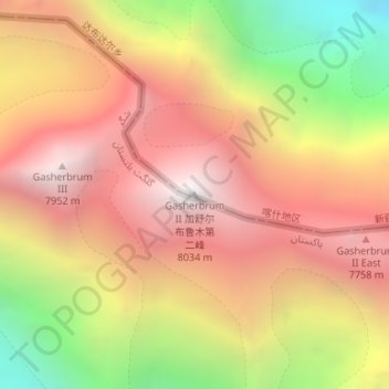
Nom : Carte topographique Gasherbrum II, altitude, relief.
Altitude moyenne : 7 098 m
Altitude minimum : 5 846 m
Altitude maximum : 7 992 m
Gasherbrum II is located on the border of Gilgit–Baltistan, Pakistan, and Xinjiang, China. It is part of the Karakoram mountain range in the Himalayas, and located at the top of the Baltoro Glacier. With an elevation of 8,034 metres (26,358 ft) it is the third-highest member of the Gasherbrum group, behind Gasherbrum I (8,080 metres or 26,510 feet) and Broad Peak (8,051 metres or 26,414 feet). Gasherbrum III is sometimes considered to be a subpeak of Gasherbrum II, because the former has a topographic prominence of only 461 metres (1,512 ft).
Autres cartes topographiques
Cliquez sur une carte pour visualiser sa topographie, son altitude et son relief.
Tashkorgan Town
China > Xinjiang > Taxkorgan Tajik Autonomous County
Tashkorgan Town, Taxkorgan Tajik Autonomous County, Kashgar Prefecture, Xinjiang, China
Altitude moyenne : 3 109 m
Dafdar
China > Xinjiang > Taxkorgan Tajik Autonomous County
Dafdar, Taxkorgan Tajik Autonomous County, Kashgar Prefecture, Xinjiang, China
Altitude moyenne : 4 416 m