
Faire un don
Équipez-vous pour votre prochaine aventure :
En tant que Partenaire Amazon, ce site perçoit une commission sur les achats éligibles sans surcoût pour vous.
Carte topographique Sankt Wendel
Cliquez sur la carte pour afficher l’altitude.
Faire un don
Équipez-vous pour votre prochaine aventure :
En tant que Partenaire Amazon, ce site perçoit une commission sur les achats éligibles sans surcoût pour vous.
Sankt Wendel
St. Wendel is situated on the river Blies west of the Bosenberg hill at an elevation of 938 feet (286 m). Its highest elevation is the Bosenberg hill at 1591 feet (485 m); the lowest is where the river Blies exits St. Wendel heading for Ottweiler at 853 feet (260 m).
Faire un don
Équipez-vous pour votre prochaine aventure :
En tant que Partenaire Amazon, ce site perçoit une commission sur les achats éligibles sans surcoût pour vous.
À propos de cette carte
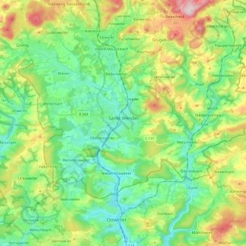
Nom : Carte topographique Sankt Wendel, altitude, relief.
Lieu : Sankt Wendel, Landkreis St. Wendel, Saarland, 66606, Germany (49.41609 7.06774 49.51141 7.30564)
Altitude moyenne : 359 m
Altitude minimum : 252 m
Altitude maximum : 589 m
Faire un don
Équipez-vous pour votre prochaine aventure :
En tant que Partenaire Amazon, ce site perçoit une commission sur les achats éligibles sans surcoût pour vous.
Autres cartes topographiques
Cliquez sur une carte pour visualiser sa topographie, son altitude et son relief.