
Carte topographique Xiangning County
Carte interactive
Cliquez sur la carte pour afficher l’altitude.
À propos de cette carte
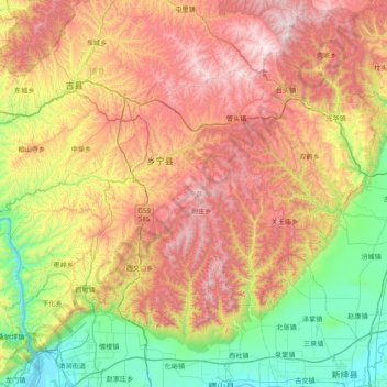
Nom : Carte topographique Xiangning County, altitude, relief.
Lieu : Xiangning County, Linfen, Shanxi, China (35.68929 110.50663 36.14994 111.28696)
Altitude moyenne : 977 m
Altitude minimum : 376 m
Altitude maximum : 1 804 m
The county is located in the Lüliang Mountains of the Loess Plateau, and has a largely hilly terrain with an average elevation of about 900 metres (3,000 ft). The county's highest point is Gaotian Mountain (Chinese: 高天山), which reaches 1,820.5 metres (5,973 ft) in altitude; the county's lowest point is along the banks of the Yellow River, at 385.1 metres (1,263 ft) in altitude.
Autres cartes topographiques
Cliquez sur une carte pour visualiser sa topographie, son altitude et son relief.
Qingxu County
China > Shanxi > Qingxu County
Qingxu County, Taiyuan City, Shanxi, China
Altitude moyenne : 913 m
Gujiao City
China > Shanxi > Gujiao City
Gujiao City, Taiyuan City, Shanxi, China
Altitude moyenne : 1 379 m
Taiyuan
China > Shanxi > Taiyuan > Sanqiao Subdistrict
Taiyuan, Sanqiao Subdistrict, Xinghualing District, Taiyuan City, Shanxi, 030002, China
Altitude moyenne : 982 m