
Carte topographique Pendowoharjo
Carte interactive
Cliquez sur la carte pour afficher l’altitude.
À propos de cette carte
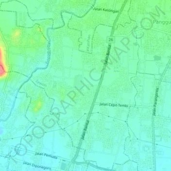
Nom : Carte topographique Pendowoharjo, altitude, relief.
Altitude moyenne : 61 m
Altitude minimum : 44 m
Altitude maximum : 119 m
Autres cartes topographiques
Cliquez sur une carte pour visualiser sa topographie, son altitude et son relief.
Pleret
Indonesia > Special Region of Yogyakarta > Bantul Regency
Pleret, Bantul Regency, Special Region of Yogyakarta, Java, Indonesia
Altitude moyenne : 131 m
Sedayu
Indonesia > Special Region of Yogyakarta > Bantul Regency
Sedayu, Bantul Regency, Special Region of Yogyakarta, Java, Indonesia
Altitude moyenne : 80 m
Banguntapan
Indonesia > Special Region of Yogyakarta > Bantul Regency
Banguntapan, Bantul Regency, Special Region of Yogyakarta, Java, Indonesia
Altitude moyenne : 91 m
Trirenggo
Indonesia > Special Region of Yogyakarta > Bantul Regency
Trirenggo, Bantul, Bantul Regency, Special Region of Yogyakarta, Java, 55714, Indonesia
Altitude moyenne : 41 m