
Carte topographique Municipal Unit of Sparta
Carte interactive
Cliquez sur la carte pour afficher l’altitude.
À propos de cette carte
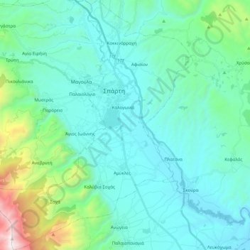
Nom : Carte topographique Municipal Unit of Sparta, altitude, relief.
Altitude moyenne : 450 m
Altitude minimum : 113 m
Altitude maximum : 2 206 m
Autres cartes topographiques
Cliquez sur une carte pour visualiser sa topographie, son altitude et son relief.
Sparta
Greece > Peloponnese, Western Greece and the Ionian > Laconia Regional Unit > Χαρίσιο
Sparta, Πλατανιστά, Χαρίσιο, Municipality of Sparta, Laconia Regional Unit, Peloponnese Region, Peloponnese, Western Greece and the Ionian, 23100, Greece
Altitude moyenne : 214 m